Northern Waterfront in San Francisco City and County, California — The American West (Pacific Coastal)
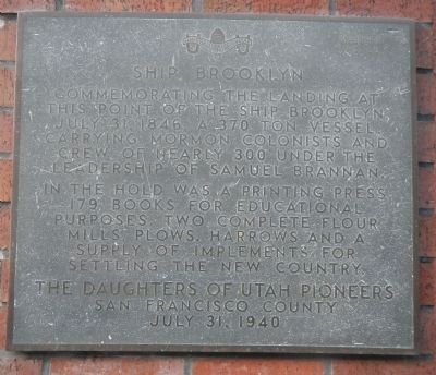
Ship Brooklyn
In the hold was a printing press, 179 books for education purposes , two complete flour mills, plows, harrows and a supply of implements for settling the new country.
Erected 1940 by Daughters of Utah Pioneers, San Francisco County. (Marker Number 60.)
Topics and series. This historical marker is listed in these topic lists: Churches & Religion • Settlements & Settlers • Waterways & Vessels. In addition, it is included in the Daughters of Utah Pioneers series list. A significant historical date for this entry is July 31, 1906.
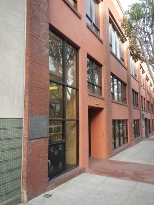
Location. 37° 47.929′ N, 122° 24.026′ W. Marker is in San Francisco, California, in San Francisco City and County. It is in Northern Waterfront. Marker is on Broadway, on the left when traveling east. Touch for map. Marker is at or near this postal address: 120 Broadway, San Francisco CA 94111, United States of America. Touch for directions.
Other nearby markers. At least 8 other markers are within walking distance of this marker. Clark’s Point (a few steps from this marker); Old Ship Saloon (about 400 feet away, measured in a direct line); 901 battery (about 500 feet away); Vallejo Street (about 700 feet away); Bemis Bag Building - 1906 (about 700 feet away); Green Street (about 800 feet away); Pony Express Wharf (approx. 0.2 miles away); Building the Seawall (approx. 0.2 miles away). Touch for a list and map of all markers in San Francisco.
Also see . . . Voyage of the “Brooklyn” - LDS Ensign. From the northeastern United States, Latter-day Saints converged in New York City in the winter of 1845–46. Lacking means to travel overland to Nauvoo, Illinois, these Saints answered the call of Church leaders to gather to the West by pooling their money and chartering a ship. Under the leadership of Brother Samuel Brannan, who had been appointed by Elder Orson Pratt of the Quorum of the Twelve Apostles, they would sail around South America’s Cape Horn to the Sandwich Islands (Hawaii) and then on to California, crossing the equator twice in the process, making perhaps the longest religious sea pilgrimage in recorded history. (Submitted on February 27, 2014, by Barry Swackhamer of Brentwood, California.)
Credits. This page was last revised on February 7, 2023. It was originally submitted on February 27, 2014, by Barry Swackhamer of Brentwood, California. This page has been viewed 688 times since then and 24 times this year. Photos: 1, 2. submitted on February 27, 2014, by Barry Swackhamer of Brentwood, California. • Syd Whittle was the editor who published this page.

