Fruitvale in Oakland in Alameda County, California — The American West (Pacific Coastal)
Union Point
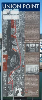
Photographed by Barry Swackhamer, February 24, 2014
1. Union Point Marker
Beginning in the 1870s, harbor improvements by the U.S. Army Corps of Engineers transformed the shallow estuary into a working harbor. Channels and basins were deepened, and the dredged mud and sand were used to fill marshes and tidelands. Coast Guard Island, north of here, was created by dumping dredged material behind levees. The excavated mile-long tidal canal, south of here, transformed Alameda from a peninsula to an island and funneled tidal water from San Leandro Bay through the estuary in order to scour the shipping channels. These harbor improvements made the estuary accessible to ocean-going vessels, ushering in a new era of marine commerce.
Farther west is Fortman Marina, the site of the berthing basin of the Alaska Packers Association – the world’s largest salmon-packing concern. Beginning in the 1890s, the company’s ships sailed
this page online
Topics. This historical marker is listed in these topic lists: Industry & Commerce • Waterways & Vessels. A significant historical year for this entry is 1922.
Location. 37° 46.628′ N, 122° 14.531′ W. Marker is in Oakland, California, in Alameda County. It is in Fruitvale. It can be reached from Embarcadero, on the right when traveling south. Touch for map. Marker is at or near this postal address: 2301 Embarcadero, Oakland CA 94606, United States of America. Touch for directions.

Regionally, this marker is in the San Francisco Bay Area and on the Coast Ranges. It is also on the American Pacific Coast. Globally, it is in North America, on the Ring of Fire, on the Pacific Rim, in the Western Hemisphere, in the Western World, and in the Anglosphere. Historically, it finds
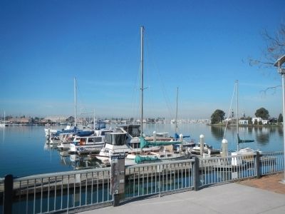
Photographed by Barry Swackhamer, February 24, 2014
2. Union Point Marker
Other nearby markers. At least 8 other markers are within walking distance of this marker: Sígame/Follow Me (within shouting distance of this marker); Cryer & Sons (about 700 feet away, measured in a direct line); ATK Baseball Field (approx. 0.4 miles away); California Cotton Mill (approx. 0.4 miles away); Tonarigumi (approx. 0.6 miles away); Ky Eybright Boathouse (approx. 0.6 miles away); a different marker also named Tonarigumi (approx. 0.7 miles away); a different marker also named Tonarigumi (approx. 0.7 miles away). Touch for a list and map of all markers in Oakland.
Another marker is no longer nearby. Early Harbor (was approx. half a mile away but has been permanently removed).
More about this marker. This marker is located in Union Point Park near the boat docks.
Credits. This page was last revised on February 7, 2023. It was originally submitted on March 4, 2014, by Barry Swackhamer of Brentwood, California. This page has been viewed 837 times since then and 29 times this year. Photos: 1, 2. submitted on March 4, 2014, by Barry Swackhamer of Brentwood, California. • Syd Whittle was the editor who published this page.
