Near La Pine in Deschutes County, Oregon — The American West (Northwest)
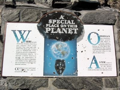
A Special Place on the Planet
Obsidian is rare and found in only a few places around the world.
Obsidian and mythology were powerfully linked. In ancient Mexico, the gentle Aztec god Ixtilto or “Little Black One” emanated from this obsidian mask which brought darkness and peaceful sleep to children in their beds.
As you come to know a little piece of the planet, even the tiniest rock can become very special to you.
Erected by United States Forest Service.
Topics. This historical marker is listed in this topic list: Natural Features.
Location. 43° 42.194′ N, 121° 14.188′ W. Marker is near La Pine, Oregon, in Deschutes County. Marker can be reached from Paulina Lake Road (NF-21), 0.7 miles east of National Forest Service Road 567 (NF-567). Marker is located on the Big Obisidian Flow Trail in the Newberry Crater unit of Newberry National Volcanic Monument; the above directions are to the intersection of Paulina Lake Road and the driveway to the Big Obsidian Flow parking lot. Touch for map. Marker is in this post office area: La Pine OR 97739, United States of America. Touch for directions.
Other nearby markers. At least 5 other markers are within 15 miles of this marker, measured as the crow flies. The Eruption (about 700 feet away, measured in a direct line); Glass Menagerie (about 800 feet away); Big Obsidian Flow (approx. 0.2 miles away); Lava River Cave (approx. 14.8 miles away); Some Lava Flows Build Their Own Pipelines (approx. 14.8 miles away).
More about this marker. Marker is the seventh of seven interpretive signs along the Big Obsidian Flow Trail.
Credits. This page was last revised on June 16, 2016. It was originally submitted on March 19, 2014, by Duane Hall of Abilene, Texas. This page has been viewed 431 times since then and 10 times this year. Photos: 1, 2, 3, 4. submitted on March 19, 2014, by Duane Hall of Abilene, Texas.
Editor’s want-list for this marker. Photo of wide-view of marker and surroundings. Photos of markers along trail missing from HMDB. • Can you help?


