Near Hulett in Crook County, Wyoming — The American West (Mountains)
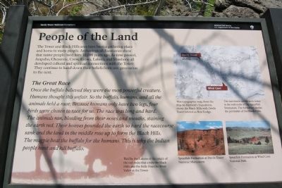
People of the Land
Devils Tower National Monument
The Great Race
Once the buffalo believed they were the most powerful creature. Humans thought this unfair. So the buffalo, humans, and all the animals held a race. Because humans only have two legs, four birds were chose to race for us. The race was long and hard. The animals ran, bleeding from their noses and mouths, staining the earth red. Their hooves pounded the earth so hard the racecourse sank and the land in the middle rose up to form the Black Hills. The magpie beat the buffalo for the humans. This is why the Indian people hunt and kill buffalo.
Told by the Lakota of the origin of the red rocks that circle the Black Hills and the Belle Fourche River Valley at the Tower.
(Map Caption)
This topographic map, from the 1859-60 Raynold’s Expedition, shows the Blacks Hills with Devils Tower labeled as Bear Lodge.
The race track can be seen today in the red rocks of the Spearfish Formation. The formation circles the perimeter of the Black Hills.
(Photo Captions)
Spearfish Formation at Devils Tower National Monument
Spearfish Formation at Wind Cave National Park
Erected by National Park Service.
Topics. This historical marker is listed in this topic list: Native Americans.
Location. 44° 35.333′ N, 104° 43.048′ W. Marker is near Hulett, Wyoming, in Crook County. Marker can be reached from State Highway 110. Marker is located in Devils Tower National Monument; drive to the end of State Route 110 to the parking lot of the Devils Tower Visitor Center. Touch for map. Marker is in this post office area: Hulett WY 82720, United States of America. Touch for directions.
Other nearby markers. At least 8 other markers are within walking distance of this marker. Buried Tower (within shouting distance of this marker); Bountiful Land (within shouting distance of this marker); How Did the Tower Form? (about 600 feet away, measured in a direct line); Friends, Family, and Fun (about 700 feet away); Devils Tower ... the first National Monument (about 700 feet away); Reach for the Top (about 800 feet away); Many Meanings for Many People (approx. 0.2 miles away); Daredevil Stunt (approx. 0.2 miles away). Touch for a list and map of all markers in Hulett.
More about this marker. Marker is along the
southwest segment of the Tower Trail which circles Devils Tower. It is a 1/3 mile walk from the Visitor Center parking lot to the marker.
Also see . . . Devils Tower National Monument. Official National Park Service website. (Submitted on March 25, 2014.)
Credits. This page was last revised on June 16, 2016. It was originally submitted on March 25, 2014, by Duane Hall of Abilene, Texas. This page has been viewed 496 times since then and 17 times this year. Photos: 1, 2, 3. submitted on March 25, 2014, by Duane Hall of Abilene, Texas.
Editor’s want-list for this marker. Photo of wide-view of marker and surroundings. • Can you help?


