South of Broad in Charleston in Charleston County, South Carolina — The American South (South Atlantic)
Black and White Worlds:
The Varied Landscapes of a Town House Lot
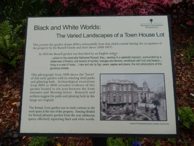
This present day garden design differs substantially from that which existed during the occupation of the property by the Russell Family and their slaves (1808-1857).
In 1819 the Russell garden was described by an English visitor:
...called on the venerable Nathaniel Russell, Esq., residing in a splendid mansion, surrounded by a wilderness of flowers, and bowers of myrtles, oranges and lemons, smothered with fruit and flowers living in a next of roses... I saw and ate rip figs, pears, apples and plums, the rich productions of this generous climate.
the photograph from 1898 shows the "bones" of this early garden with its winding shell paths and planting beds. Archaeological excavations from 2003 and 2006 revealed evidence of this garden located in the area between the front entrance and Meeting Street. Research and artifacts suggest the paths and planting beds in this image are original.
The formal, front garden was in stark contrast to the work space at the rear of the property. Fencing divided the formal pleasure garden from the rear utilitarian spaces, effectively separating black and white worlds.
Erected by Historic Charleston Foundation.
Topics. This historical marker is listed in these topic lists: African Americans • Agriculture. A significant historical year for this entry is 1819.
Location. 32° 46.427′ N, 79° 55.86′ W. Marker is in Charleston, South Carolina, in Charleston County. It is in South of Broad. Marker can be reached from Meeting Street. Touch for map. Marker is at or near this postal address: 51 Meeting Street, Charleston SC 29401, United States of America. Touch for directions.
Other nearby markers. At least 8 other markers are within walking distance of this marker. The Landscape of the Enslaved (a few steps from this marker); Nathaniel Russell House (within shouting distance of this marker); The Site of Colleton Bastion (within shouting distance of this marker); Timothy Ford's House (within shouting distance of this marker); The First Presbyterian Church of Charleston (within shouting distance of this marker); Old St. Michael’s Rectory (within shouting distance of this marker); 37 Meeting Street (about 300 feet away, measured in a direct line); William Harvey House (about 300 feet away). Touch for a list and map of all markers in Charleston.
Credits. This page was last revised on February 16, 2023. It was originally submitted on April 23, 2014, by Bill Pfingsten of Bel Air, Maryland. This page has been viewed 647 times since then and 23 times this year. Photos: 1, 2, 3, 4. submitted on April 23, 2014, by Bill Pfingsten of Bel Air, Maryland.


