Enon in Chesterfield County, Virginia — The American South (Mid-Atlantic)
Opening Actions of the Bermuda Hundred Campaign
The Bermuda Hundred Campaign
Inscription.
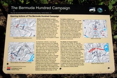
Battles at Port Walthall Junction
At about 4:00 PM on May 6, 1864 Brig. Gen. Charles Heckman's brigade moved down Ruffin Mill Road toward Port Walthall Junction where 600 soldiers from Brig. Gen. Johnson Hagood's South Carolina brigade awaited in a sunken road (Woods Edge Road today). Under strict orders not to bring on a general engagement, Heckman deployed his brigade and attacked with the 9th New Jersey regiment. The attack did not dislodge the South Carolinians and Heckman returned his brigade to Cobb's Hill that evening.
As Heckman withdrew, more South Carolina troops arrived at Port Walthall Junction. They were joined by Brig. Gen. Bushrod Johnson's Tennessee brigade with 1,200 men. This combined force fell back behind the Richmond & Petersburg Railroad. On May 7, 1864 the Federals attacked toward the railroad with four brigades totaling 8,000 men. The Federals were again unable to dislodge the Confederates and returned to their earthworks after destroying a small stretch of the rail line. That evening, Hagood's and Johnson's brigades marched down the Richmond-Petersburg Turnpike to a better defensive position south of Swift Creek. The battles of Port Walthall Junction took place where the Walthall interchange is today on l-95.
The Battle of Swift Creek
On May 9, Federal troops again moved toward Port Walthall Junction. After destroying buildings and track at Chester Station, they marched south and made contact with Confederate forces where present day Rt.1 crosses Swift Creek. Due to conflicting orders, South Carolina troops mistakenly attacked the much larger Federal force and suffered devastating losses. That evening Maj. Gen. Butler decided to disengage and return his army to the Federal lines in Bermuda Hundred to prepare for an advance on Richmond.
The Battle of Chester Station
On the morning of May 10, while the Army of the James was moving back to its Bermuda Hundred lines. Brig. Gen. Seth Barton's Virginia brigade and Brig. Gen. Archibald Gracie's Alabama brigade attacked rear guard elements of the Federal 10th Corps at Chester Station (Near the intersection of present day Rt.1 and Rt. 10). The attack broke one Federal regiment and captured a section of artillery. Three Federal brigades marching from Swift Creek were diverted to Chester Station and arrived just in time to restore the line and recapture the lost artillery. The Confederates broke contact and returned to Drewry's Bluff.
(captions)
First Battle of Port Walthall Junction
Second Battle of Port Walthall Junction
Battle of Swift Creek
Battle of Chester Station
Maps courtesy of Chesterfield Historical Society of Virginia
This
sign was sponsored by Carol and Benjamin Buckley, Fairfax Station, VA
Erected 2014 by Chesterfield County and the Blue & Gray Education Society.
Topics. This historical marker is listed in this topic list: War, US Civil. A significant historical month for this entry is May 1864.
Location. 37° 19.234′ N, 77° 21.185′ W. Marker is in Enon, Virginia, in Chesterfield County. Marker can be reached from Enon Church Road (Virginia Route 746) west of Bermuda Orchard Lane, on the left when traveling west. Located in Point of Rocks Park. Touch for map. Marker is in this post office area: Chester VA 23836, United States of America. Touch for directions.
Other nearby markers. At least 8 other markers are within walking distance of this marker. Grant's Virginia Campaigns (here, next to this marker); Point of Rocks (approx. 0.2 miles away); Welcome to R. Garland Dodd Park at Point of Rocks (approx. 0.2 miles away); Confederate Leaders (approx. 0.2 miles away); The Bermuda Hundred Campaign-Federal Leaders (approx. 0.2 miles away); The Bermuda Hundred Campaign Begins (approx. 0.2 miles away); Federal War Plans for 1864 (approx. 0.3 miles away); Actions in the East 1861-1863 (approx. 0.3 miles away). Touch for a list and map of all markers in Enon.
Credits. This page was last revised on June 16, 2016. It was originally submitted on May 25, 2014, by Bernard Fisher of Richmond, Virginia. This page has been viewed 846 times since then and 35 times this year. Photos: 1, 2. submitted on May 25, 2014, by Bernard Fisher of Richmond, Virginia.

