Drytown in Amador County, California — The American West (Pacific Coastal)
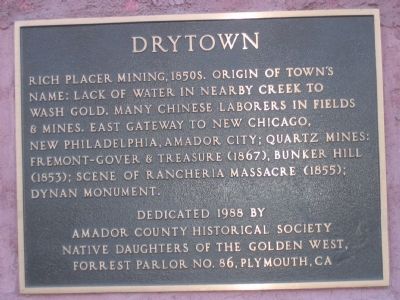
Drytown
Erected 1988 by Amador County Historical Society, Native Daughters of the Golden West, Forrest Parlor No. 86, Plymouth,Ca.
Topics and series. This historical marker is listed in this topic list: Cemeteries & Burial Sites. In addition, it is included in the Native Sons/Daughters of the Golden West series list.
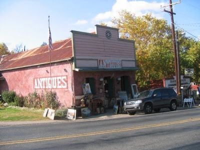
Location. 38° 26.462′ N, 120° 51.312′ W. Marker is in Drytown, California, in Amador County. Marker is on Hanford Street (State Highway 49), on the right when traveling south. Marker is on a building now used as an antique store. Touch for map. Marker is in this post office area: Drytown CA 95699, United States of America. Touch for directions.
Other nearby markers. At least 8 other markers are within 3 miles of this marker, measured as the crow flies. Early Day Butcher Shop (a few steps from this marker); Salute to Early Amador Miners (within shouting distance of this marker); a different marker also named Drytown (approx. 0.2 miles away); New Chicago (approx. 1.1 miles away); Fremont-Gover Mine (approx. 1.3 miles away); Treasure Mine (approx. 1.6 miles away); Bunker Hill Mine (approx. 2 miles away); Amador City Cemetery (approx. 2.2 miles away). Touch for a list and map of all markers in Drytown.
Also see . . . The Last Californian: An Historical Novel of the Rancheria Massacre. This book, originally published in 1987, is an historical novel regarding the 1855 Rancheria Massacre. A Joaquin Murietta outlaw band killed several local residents, including some from the Dynan family who operated a hotel in nearby Lower Rancheria.
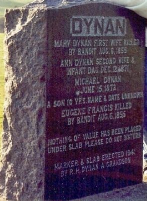
A roadside granite marker, near the Rancheria Massacre site, marks the graves of Dynan family members, including Mary who was one of those killed by bandits on Aug 6, 1855. This work of remembrance was erected in 1941 R. H. Dynan, a grandson of Michael Dynan. (Submitted on August 19, 2008, by Kevin W. of Stafford, Virginia.)
Additional commentary.
1. Dynan Family
Norma McCabe (granddaughter of R.H. Dynan and contributor of photos #3 and #4) supplied the following information:
“The Last Californian” publication states that John was the proprietor of the Dynan Hotel. This information is incorrect. John was the son of Michael Dynan and his second wife, Ann.
— Submitted February 16, 2009, by Syd Whittle of Mesa, Arizona.
2. The Dynan Monument
Rancheria Massacre: Not many monuments recall the racial animosity of California's Gold Rush history.
One that does is virtually impossible to find, and only obliquely refers to the tragic episode associated with it.
It rises from a long, convex slab of concrete high on a slope of private cattle land east of Drytown in Amador County.
The lonely monument overlooks the site of Lower Rancheria, the setting for the start of perhaps the bloodiest encounter between California Mexicans and immigrant gringos who disrupted their lives.
In 1855, about a dozen displaced Californians, most of them Mexicans, revolted.
In one day they killed six people and robbed several Chinese mining camps in and about Lower Rancheria.
That was just the start of a virtual race war along the foothills, with innocent Mexicans killed, the Chilean neighborhood of Drytown burned, and Amador County's first sheriff, William Phoenix, mortally wounded in a gunbattle.
Before calm was restored to the area, as many as 17 Mexicans may have been killed and all others had been expelled from the county.
The tombstone pays tribute to two of the victims, Mary Dynan and Eugene Francis, both "killed by bandit" on Aug. 5, 1855.
Source:
http://www.calgoldrush.com/lb_sets/01maptopast.html
— Submitted February 28, 2009, by Syd Whittle of Mesa, Arizona.
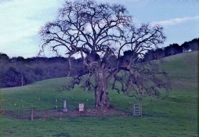
3. "Parsons Plot" Cemetery Site Seen in Photo No. 3
Captain Nathaniel Parsons was an early resident of Lower Rancheria and was present at the August 1855 “incident”. He was the proprietor of the Rancheria House sometime after 1855. He owned the land, having homesteaded it in 1864, where the cemetery is located. This cemetery is referred to by descendants as the "Parsons Plot".
The first burial in the cemetery was Julia Miller (1875 - infant grand-daughter of Nathaniel. She was 15 days old.) The second burial was Harriet (Parsons) Miller (1838 – 1878, daughter of Nathaniel, mother of the infant Julia, and wife of J. H. Miller.) The third burial was Mary Ann (Badger) Parsons, (1805 - 1879, wife of Nathaniel), and the fourth burial was Nathaniel, (1801 - 1886) the Patriarch.
Upon Nathaniel’s death in 1886, the land was occupied by his son-in-law John Howe Miller (husband of Harriet who had passed in 1878) and his family.
Subsequent family members are also at rest in this cemetery.

Photographed By N. McCabe, May 2000
4. Dynan Monument Mentioned on Marker
Note: Marker is located on private property on Turner Road between New Chicago and Mayflower Roads.
Sometime before 1975 the cemetery was desecrated and the marble headstones of both Nathaniel and Mary Ann were removed by the vandals. There are wooden markers there today (2009) that incorrectly identify Nathaniel Parsons' year of death as 1866, when it was actually 1886. Capt. Parsons and Mary Ann celebrated their Golden Wedding Anniversary in Amador City in 1878. Nathaniel was my gr3 grandfather. I have donated his portrait and invitation to the Golden Wedding Ball held January 7, 1878, to the Amador Archives, where it was hanging on the wall in January, 2009. Note To Editor only visible by Contributor and editor
— Submitted August 13, 2009, by Bill Baccus of Temecula, California.
4. Nathaniel Parsons
The current (2014) wooden marker for Nathaniel Parsons now correctly shows his year of death's as 1886.
Editor's note: Thank you for this updated information. SW
— Submitted November 7, 2014, by Mark Bowlby of San Jose, California.
Credits. This page was last revised on June 16, 2016. It was originally submitted on August 18, 2008, by Syd Whittle of Mesa, Arizona. This page has been viewed 4,087 times since then and 59 times this year. Last updated on June 1, 2014, by Bill Baccus of Temecula, California. Photos: 1, 2. submitted on August 18, 2008, by Syd Whittle of Mesa, Arizona. 3, 4. submitted on February 16, 2009, by Syd Whittle of Mesa, Arizona.


