Ehrhardt in Bamberg County, South Carolina — The American South (South Atlantic)
Battle of Rivers' Bridge
Feb. 2-3, 1865
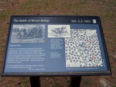
As Mower's troops flanked the Confederate right, another Union division crossed several miles downstream to flank the Confederate left. Under a smokescreen created by a rapid artillery and rifle volleys, the Southerners withdrew. Before the retreat, a Union sharpshooter crawled close to the Confederate cannons and killed Lt. Simeon S. Kirby. Pvt. W.M. Larke borrowed a rifle to shoot the Yankee. "I took aim at the fellow and hollered at him," Larke recalled. "When he looked up I shot him clear through."
" It was with difficulty that my command could be withdrawn, as I was completely flanked on both sides."
- Maj. Gen. Lafayette McLaws
Erected by South Carolina State Park Service.
Topics. This historical marker is listed in these topic lists: Military • Notable Events • War, US Civil.
Location. 33° 3.151′ N, 81° 6.016′ W. Marker is in Ehrhardt, South Carolina, in Bamberg County. Marker can be reached from SC-S-5-8. Located in the Rivers Bridge State Park, a mile south of SC-S-5-31. Touch for map. Marker is in this post office area: Ehrhardt SC 29081, United States of America. Touch for directions.
Other nearby markers. At least 8 other markers are within walking distance of this marker. A different marker also named Battle of Rivers' Bridge (within shouting distance of this marker); a different marker also named Battle of Rivers' Bridge (within shouting distance of this marker); a different marker also named Battle of Rivers' Bridge (within shouting distance of this marker); a different marker also named Battle of Rivers' Bridge (about 400 feet away, measured in a direct line); a different marker also named Battle of Rivers' Bridge (about 500 feet away); a different marker also named Battle of Rivers' Bridge (about 500 feet away); a different marker also named Battle of Rivers' Bridge (about 600 feet away); a different marker also named Battle of Rivers' Bridge (about 700 feet away). Touch for a list and map of all markers in Ehrhardt.
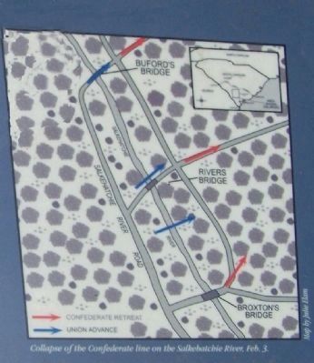
Regarding Battle of Rivers' Bridge. In the upper left is a drawing of an artillery piece in action. Two of the four cannons fired from the flat area in front of you. In the upper center a drawing of Confederate cavalry is captioned, During the Confederate retreat, a squad from the 3rd South Carolina Cavalry accidentally rode into advancing Union soldiers. Two were captured. The other two escaped by hard riding. On the right is a map by Julie Elam depicting the Collapse of the Confederate line on the Salkehatchie River, Feb. 3.
Credits. This page was last revised on June 16, 2016. It was originally submitted on April 29, 2008, by Mike Stroud of Bluffton, South Carolina. This page has been viewed 1,518 times since then and 27 times this year. Photos: 1, 2, 3. submitted on April 29, 2008, by Mike Stroud of Bluffton, South Carolina. • Craig Swain was the editor who published this page.


