
Sainte-Claire in Bellechasse, Québec — Central Canada (French-Canadian)
Sainte-Claire (Dorchester)
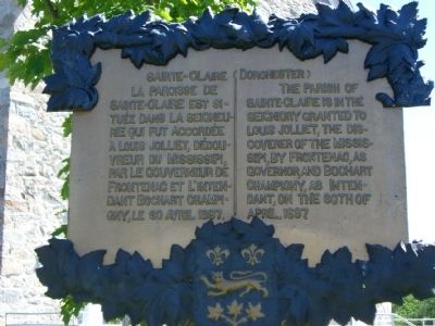
Photographed by J.P. Wells, circa 2007
1. Sainte-Claire (Dorchester) Marker

Topics. This historical marker is listed in these topic lists: Colonial Era • Religion & Religious Structures • Settlements & Settlers • Waterways & Vessels. A significant historical date for this entry is April 30, 1697.
Location. 46° 35.862′ N, 70° 52.07′ W. Marker is in Sainte-Claire, Québec, in Bellechasse. It is at the intersection of Principale Street and de l'Église Street, on the right when traveling east on Principale Street. The marker is located on the front lawn of the Sainte-Claire Catholic church, which was built in 1824. Touch for map. Marker is at or near this postal address: 134 Principale Street, Sainte-Claire QC G0R 2V0, Canada. Touch for directions.

Regionally, this marker is in Central
this page online
More about this marker. It is interesting to note that the marker misspells the word "Mississippi" both in French and in English.

Photographed by J. Titolo, circa May 2014
2. Sainte-Claire (Dorchester) Marker
Credits. This page was last revised on January 23, 2022. It was originally submitted on June 28, 2014, by Kevin Craft of Bedford, Quebec. This page has been viewed 1,559 times since then and 140 times this year. Photos: 1, 2. submitted on June 28, 2014, by Kevin Craft of Bedford, Quebec. • Bill Pfingsten was the editor who published this page.
