Paul Smiths in Franklin County, New York — The American Northeast (Mid-Atlantic)
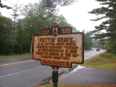
Pettis' Grave
Erected 1935 by New York State Education and Conservation Departments.
Topics. This historical marker is listed in these topic lists: Cemeteries & Burial Sites • Horticulture & Forestry.
Location. 44° 26.409′ N, 74° 14.806′ W. Marker is in Paul Smiths, New York, in Franklin County. Marker is on New York State Route 86, 0.3 miles east of New York State Route 30 when traveling east. Touch for map. Marker is in this post office area: Paul Smiths NY 12970, United States of America. Touch for directions.
Other nearby markers. At least 8 other markers are within 10 miles of this marker, measured as the crow flies. The Site of Camp S-60 (approx. 0.3 miles away); Forest Fire (approx. 5.7 miles away); The Union Depot (approx. 9˝ miles away); Making History in Saranac Lake (approx. 9˝ miles away); a different marker also named Making History in Saranac Lake (approx. 9˝ miles away); Hotel Saranac (approx. 9.7 miles away); Trudeau Memorial (approx. 9.7 miles away); a different marker also named Making History in Saranac Lake (approx. 9.7 miles away). Touch for a list and map of all markers in Paul Smiths.
Credits. This page was last revised on November 27, 2019. It was originally submitted on July 21, 2014, by Dominic Morrell of Dover, Delaware. This page has been viewed 539 times since then and 18 times this year. Last updated on July 27, 2014, by Anton Schwarzmueller of Wilson, New York. Photo 1. submitted on July 21, 2014, by Dominic Morrell of Dover, Delaware. • Bill Pfingsten was the editor who published this page.
