Ogdensburg in St. Lawrence County, New York — The American Northeast (Mid-Atlantic)
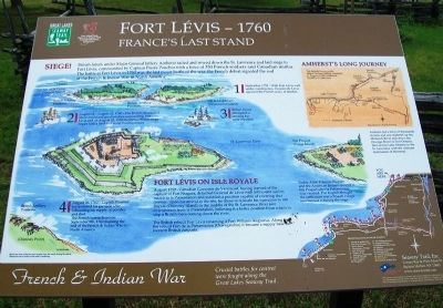
Fort Lévis - 1760
France's Last Stand
— French & Indian War —
Father Abbé François Picquet and the American Indians moved to Isle Picquet after la Présentation was vacated. The English thought the settlement was a French village and burned it during the siege.
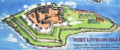
Fort Lévis on Isle Royale
August 1759 - Canadian Governor de Vandreuil, having learned of the capture of Fort Niagara, detached General de Lévis with 500 to 600 men to march to la Présentation and established a position capable of covering that frontier. Upon his arrival at the site, he chose to relocate his operation to Isle Royale (Chimney Island) in the middle of the St. Lawrence River just downstream from la Présentation, believing it a better position from which to stop a British force coming down the river.
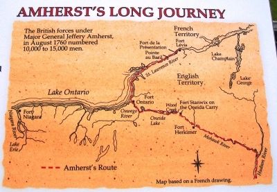
Amherst's Long Journey
The British forces under Major General Jeffery Amherst, in August 1760 numbered 10,000 to 15,000 men.
Amherst led a force of thousands of men and materiel up the Mohwak River and down the Oswego River to Fort Ontario, then across Lake Ontario to the St. Lawrence with the ultimate destination of Montreal.
Siege!
British forces under Major General Jeffery Amherst sailed and rowed down the St. Lawrence and laid siege to Fort Lévis, commanded by Captain Pierre Pouchot with a force of 350 French soldiers and Canadian militia. The battle at Fort Lévis in 1760 was the last major battle of the war, the French defeat signaled the end of the French & Indian War in North America.
1. September 1759 - With Fort Lévis well under construction, General de Lévis rejoined the French army at Quebec.
2. August 18 - August 22, 1760 - The British established shore and island gun batteries surrounding Fort Lévis and on August 22, 1760 the formal British siege began with a land and water bombardment.
3. British forces attempted a landing but were repelled.
4. August 26, 1760 - Captain Pouehot surrendered his garrison after exhausting his supply of powder and shot. The French surrendered on September 8th, 1760 marking the end of the French & Indian War in North America.
The British rebuilt Fort Lévis renaming it Fort William Augustus. Along with the rebuilt Fort la Présentation (Oswegatchie) it became a supply base for western British outposts.
Erected by Seaway Trail, Inc.
Topics and series. This historical marker is listed in these topic lists: Forts and Castles • Man-Made Features • War, French and Indian. In addition, it is included in the Great Lakes Seaway Trail National Scenic Byway series list. A significant historical month for this entry is September 1759.
Location. 44° 41.667′ N, 75° 30.073′ W. Marker is in Ogdensburg, New York, in St. Lawrence County. Marker is on the Downtown Arterial (New York State Route 68) west of Commerce Street, on the right when traveling west. Touch for map. Marker is in this post office area: Ogdensburg NY 13669, United States of America. Touch for directions.
Other nearby markers. At least 8 other markers are within walking distance of this marker. Fort la Présentation (here, next to this marker); Fort de la Présentation - 1749-1759 (here, next to this marker); Fort Oswegatchie 1760-1796 (here, next to this marker); The Battle of Ogdensburg (here, next to this marker); Aka Se We':Ka Tsi (Oswegatchie) (here, next to this marker); Fort de la Présentation (here, next to this marker); Abbe Picquet 1708 -1781 (about 400 feet away, measured in a direct line); Mission Fort (about 500 feet away). Touch for a list and map of all markers in Ogdensburg.
Also see . . . Fort Levis. (Submitted on July 29, 2014, by William Fischer, Jr. of Scranton, Pennsylvania.)
Credits. This page was last revised on June 16, 2016. It was originally submitted on July 29, 2014, by William Fischer, Jr. of Scranton, Pennsylvania. This page has been viewed 585 times since then and 41 times this year. Photos: 1, 2, 3. submitted on July 29, 2014, by William Fischer, Jr. of Scranton, Pennsylvania. 4. submitted on July 28, 2014, by William Fischer, Jr. of Scranton, Pennsylvania.


