Ulmer in Bamberg County, South Carolina — The American South (South Atlantic)
Buford's Bridge
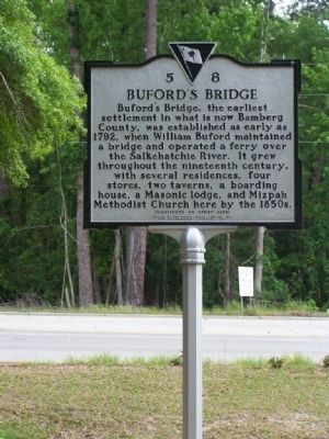
Buford's Bridge, the earliest settlement in what is now Bamberg County, was established as early as 1792, when William Buford maintained a bridge and operated a ferry over the Salkehatchie River. It grew throughout the nineteenth century, with several residences, four stores, two taverns, a boarding house, a Masonic lodge, and Mizpah Methodist Church here by the 1850s.
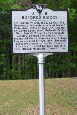
( Reverse Text)
On February 3-5, 1865, as Gen.W.T. Sherman's Federals advanced toward Columbia, units of Gen. J. A. Logan's XV Corps approached Buford's Bridge. Gen. Joseph Wheeler's Confederate cavalry burned the bridge, then evacuated the earthworks here before Logan arrived on Feb. 4th. Federals destroyed most of the buildings in the area to build bridges and left only Mizpah Methodist Church in tact.
Erected 2002 by The Rivers Bridge Camp No. 842, Sons of Confederate Veterans. (Marker Number 5-8.)
Topics and series. This historical marker is listed in these topic lists: Settlements & Settlers • War, US Civil. In addition, it is included in the Sons of Confederate Veterans/United Confederate Veterans series list. A significant historical year for this entry is 1792.
Location. 33° 7.034′ N, 81° 10.952′ W. Marker is in Ulmer, South Carolina, in Bamberg County. Marker is at the intersection of Burton Ferry Road (U.S. 301) and Carolina Highway (U.S. 321), on the right when traveling north on Burton Ferry Road. Touch for map. Marker is in this post office area: Ulmer SC 29849, United States of America. Touch for directions.
Other nearby markers. At least 8 other markers are within 7 miles of this marker, measured as the crow flies. Mizpah Church (approx. ¼ mile away); Olar S.C. (approx. 4.4 miles away); Bethel Baptist Church (approx. 5½ miles away); Old St. Nicholas Cemetery (approx. 6.1 miles away); Battle Of Rivers’ Bridge (approx. 6.3 miles away); Battle of Rivers' Bridge (approx. 6.4 miles away); a different marker also named Battle of Rivers' Bridge (approx. 6.4 miles away); a different marker also named Battle of Rivers' Bridge (approx. 6.4 miles away).
Regarding Buford's Bridge. Bufords Bridge,was action during the Rivers' Bridge Battle
Photographed By Mike Stroud, May 2008
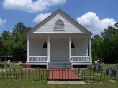
5. Mizpah Methodist Church, as mentioned on marker
The only building left from the old town of Buford
Bridge, the original building dating from about 1851. The church and cemetery are located just of Hwy 301 less about a mile north of the Salkehatchie River, and many of the early families of Buford Bridge are buried here, including the families of Ayer, Brabham, Kearse, Kirkland, Neeley, Main, Milhous, Rodt, & Weekley.
Credits. This page was last revised on June 16, 2016. It was originally submitted on May 7, 2008, by Mike Stroud of Bluffton, South Carolina. This page has been viewed 6,326 times since then and 230 times this year. Photos: 1, 2, 3, 4, 5, 6. submitted on May 7, 2008, by Mike Stroud of Bluffton, South Carolina. • Craig Swain was the editor who published this page.
