Charleston in Kanawha County, West Virginia — The American South (Appalachia)
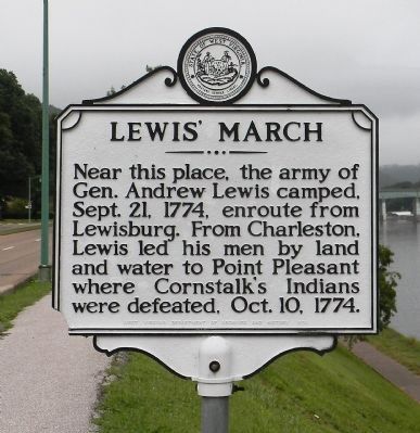
Lewis’ March
Erected 1974 by West Virginia Department of Archives and History.
Topics and series. This historical marker is listed in these topic lists: Colonial Era • Settlements & Settlers • Wars, US Indian. In addition, it is included in the West Virginia Archives and History series list. A significant historical date for this entry is September 21, 1767.
Location. 38° 20.087′ N, 81° 36.394′ W. Marker is in Charleston, West Virginia, in Kanawha County. Marker is at the intersection of Kanawha Boulevard East (U.S. 60) and Veazey Street, on the right when traveling east on Kanawha Boulevard East. The marker is located on the north levee of the Kanawha River. Touch for map. Marker is in this post office area: Charleston WV 25311, United States of America. Touch for directions.
Other nearby markers. At least 8 other markers are within walking distance of this marker. Thomas J. Jackson (approx. ¼ mile away); West Virginia Home Guards (approx. ¼ mile away); The New Deal In Your Community (approx. ¼ mile away); State Capitol (approx. 0.3 miles away); Dedicated to You, A Free Citizen in a Free Land (approx. 0.3 miles away); Abraham Lincoln Walks At Midnight (approx. 0.3 miles away); Abraham Lincoln (approx. 0.3 miles away); Zero Mile Stone (approx. 0.3 miles away). Touch for a list and map of all markers in Charleston.
Related markers. Click here for a list of markers that are related to this marker. To better understand the relationship, study each marker in the order shown.
Also see . . . e-WV | Dunmore’s War. (Submitted on September 2, 2014, by PaulwC3 of Northern, Virginia.)
Credits. This page was last revised on August 12, 2021. It was originally submitted on September 2, 2014, by PaulwC3 of Northern, Virginia. This page has been viewed 536 times since then and 23 times this year. Photos: 1, 2. submitted on September 2, 2014, by PaulwC3 of Northern, Virginia.

