Malden in Kanawha County, West Virginia — The American South (Appalachia)
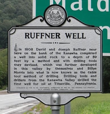
Ruffner Well
Erected 1963 by The W. Va. Centennial Committee of the oil and natural gas industry
West Virginia Historic Commission. (Marker Number X-2.)
Topics and series. This historical marker is listed in this topic list: Science & Medicine. In addition, it is included in the West Virginia Archives and History series list. A significant historical year for this entry is 1808.
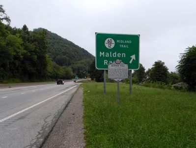
Location. 38° 18.161′ N, 81° 33.367′ W. Marker is in Malden, West Virginia, in Kanawha County. Marker is at the intersection of Kanawha Boulevard East (U.S. 60) and Georges Drive, on the right when traveling south on Kanawha Boulevard East. The marker is located next to the east-bound deceleration lane for Malden (Midland Trail) exit. Touch for map. Marker is in this post office area: Charleston WV 25306, United States of America. Touch for directions.
Other nearby markers. At least 8 other markers are within 3 miles of this marker, measured as the crow flies. Rev. Ruffner's Grave (about 700 feet away, measured in a direct line); African Zion Baptist Church (approx. ¼ mile away); Lewis Ruffner (approx. ¼ mile away); The Necessary Ingredient (approx. ¼ mile away); Booker T. Washington (approx. ¼ mile away); a different marker also named Booker T. Washington (approx. 0.3 miles away); Burning Spring Monument (approx. 2.3 miles away); Daniel Boone (approx. 2½ miles away). Touch for a list and map of all markers in Malden.
Also see . . . WVGES Geology: History of West Virginia Salt Industry. (Submitted on September 3, 2014, by PaulwC3 of Northern, Virginia.)
Credits. This page was last revised on July 6, 2020. It was originally submitted on September 3, 2014, by PaulwC3 of Northern, Virginia. This page has been viewed 475 times since then and 27 times this year. Photos: 1, 2. submitted on September 3, 2014, by PaulwC3 of Northern, Virginia.
Editor’s want-list for this marker. Picture of the Ruffner Well site at the mouth of Campbell Creek on the Kanawha River in Port Amherst. • Can you help?

