Sidney in Cheyenne County, Nebraska — The American Midwest (Upper Plains)
Fort Sidney
Photographed by Barry Swackhamer, May 23, 2014
1. Fort Sidney Marker
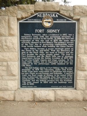
Sidney Barracks, when established in 1867, was a temporary camp with one permanent structure, a blockhouse located to the north. In 1869 the Fort was relocated at this site and in 1870 the name was officially changed to Fort Sidney. The primary service of the Fort was in protecting construction crews from hostile Indians while building the Union Pacific.
Fort Sidney became a major strategic point on the Plains in the mid-1870’s. With the discovery of gold in the Black Hills, the town of Sidney and the Fort became the major supply point. The trail to Fort Robinson and the Black Hills was of strategic importance during the Indian troubles of 1874-1877 in serving freight wagons and stage coaches. At the same time, Sidney was an important trail town and railhead in the picturesque cattle business of the Old West.
The last Indian alarm at Fort Sidney was the most dramatic. In 1878 the Cheyenne, under Dull Knife, broke from their reservation in Oklahoma and staged an epic flight across Kansas and Nebraska. A special train was kept ready at Sidney to be rushed either way to intercept the Indians when they came to the Union
this page online
Erected by Sidney Kiwanis Club and Historical Land Mark Council. (Marker Number 16.)
Topics and series. This historical marker is listed in these topic lists: Forts and Castles • Wars, US Indian. In addition, it is included in the Nebraska State Historical Society series list. A significant historical month for this entry is October 1942.
Location. 41° 8.693′ N, 102° 58.153′ W. Marker is in Sidney, Nebraska, in Cheyenne County. It is at the intersection of Illinois Street (aka Lincoln Highway) (U.S. 30) and Ball Street, on the right when traveling east on Illinois Street (aka Lincoln Highway). Touch for map. Marker is in this post office area: Sidney NE 69162, United States of America. Touch for directions.

Regionally, this marker is in the Nebraska Panhandle. It is also in the American Midwest, in the Corn Belt, on the prairies, on the Great Plains, and specifically on the High Plains. Globally, it is in North America, the Western Hemisphere, the Western World,
Photographed by Barry Swackhamer, May 23, 2014
2. Fort Sidney Marker
Other nearby markers. At least 8 other markers are within 4 miles of this marker, measured as the crow flies: Carnegie Library (approx. ¼ mile away); Original Site of Boot Hill Cemetery (approx. 0.4 miles away); Hickory Square (approx. 0.4 miles away); Nebraska’s Earliest Documented Burial (approx. 0.9 miles away); Sidney-Black Hills Trail (approx. 1.6 miles away); National Pony Express Monument (approx. 2.2 miles away); 385 Gold Rush Byway (approx. 2.2 miles away); Cheyenne County (approx. 3.1 miles away). Touch for a list and map of all markers in Sidney.
Also see . . .
1. Fort Sidney. Wikipedia entry (Submitted on November 21, 2024, by Larry Gertner of New York, New York.)
2. Fort Sidney - Fortwiki. Fort Sidney (1867-1894) - First established in 1867 at Sidney, Nebraska, by Captain Bernard P. Mimmack, 30th Infantry, as Sidney Barracks, a sub post of Fort Sedgwick in Colorado. The post became independent in 1870. Renamed Fort Sidney, 30 Dec 1878, after Sidney Dillon, New York attorney for the Union Pacific Railroad. Abandoned in 1894. (Submitted on September 3, 2014, by Barry Swackhamer of Brentwood, California.)
Credits. This page was last revised on November 21, 2024. It was originally submitted on September 3, 2014, by Barry Swackhamer of Brentwood, California. This page has been viewed 1,281 times since then and 58 times this year. Photos: 1, 2. submitted on September 3, 2014, by Barry Swackhamer of Brentwood, California. • Andrew Ruppenstein was the editor who published this page.
