Atlantic Beach in Carteret County, North Carolina — The American South (South Atlantic)
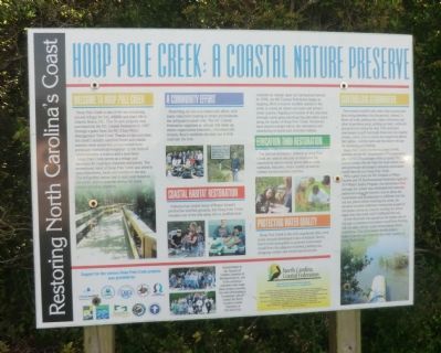
Hoop Pole Creek: A Coastal Nature Preserve
Restoring North Carolina’s Coast
Welcome to Hoop Pole Creek
Hoop Pole Creek is one of the last remaining natural refuges for fish, wildlife and plant life in Atlantic Beach, NC. This 31-acre property was purchased by the NC Coastal Federation in 1997 through a grant from the NC Clean Water Management Trust Fund. Thanks to this purchase, the creek’s healthy maritime forest and coastal marshes were preserved and protected from previously intended development in the form of condominiums, a marina and a boat basin.
Hoop Pole Creek serves as a refuge and sanctuary for countless creatures and plants. The recreational value of Hoop Pole Creek also attracts many fisherman, locals and tourists to the site. The self guided nature trail is open year-around to the public and is a popular retreat from many visitors and local residents.
A Community Effort
Preserving the site is a community effort, with many volunteers helping to create and maintain the self-guided nature trail. The NC Coastal Federation organizes an annual trail clean up where organization members, volunteers and Atlantic Beach residents all come out to help maintain the trail.
Coastal Habitat Restoration
Pollution has closed many of Bogue Sound’s productive shellfish grounds, but Hoop Pole Creek remains one of the few areas where shellfish beds consistently remain open for commercial harvest. In 1998, the NC Coastal Federation began an ongoing effort to restore shellfish habitat in the creek to create an oyster sanctuary and protect water quality. Ongoing restoration of the shoreline through marsh grass plantings has also taken place along the banks of Hoop Pole Creek. Volunteers have played a major role in the restoration and monitoring of oyster and shoreline habitat.
Education Thru Restoration
The various restoration projects at Hoop Pole Creek are used to educate students and the community about coastal plants and animals, wetlands, estuaries, water quality, as well as current environmental concerns.
Protecting Water Quality Hoop Pole Creek is the only unpolluted tidal creek in the densely developed town of Atlantic Beach, but it is still susceptible to polluted stormwater runoff from the adjacent roadway, parking lots, shopping centers and residential structures.
Controlling Stormwater
Stormwater runoff is rain water that is preserved from being absorbed into the ground, instead, it flows off roads, parking lots, roads, driveways and other impervious areas, picking up trash, sediment and pollutants along the way. This untreated stormwater runoff eventually flows into the nearest stream, creek, river or ocean and negatively affects fish habitat, shellfish beds and the waters we use for swimming and fishing.
Hoop Pole Creek is home to a large culvert, installed by the NC Department of Transportation prior to NCCF’s purchase of the property. This culvert crosses the site from the main island road and previously discharged untreated stormwater runoff directly into Hoop Pole Creek.
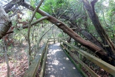
With a grant from the NC Division of Water Quality and US Environmental Protection Agency’s 319 Water Quality Program, the stormwater flow through the culvert was eliminated and naturally redirected across the forested area to allow the stormwater and its pollutants to infiltrate into the soil and plants before reaching the creek. An elevated wooden walkway constructed as part of the project serves as a barrier holding the water away from the creek until it infiltrates the soil.
A riser structure was placed on the intake side of the pipe to prevent stormwater runoff from flowing into the pipe, except under extraordinary flood conditions. This stormwater retrofit project helps to protect and improve the water quality of Hoop Pole Creek.
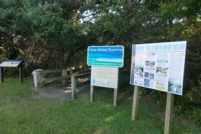
Erected by NC Coastal Federation and the NC Clean Water Management Trust.
Topics. This historical marker is listed in these topic lists: Environment • Waterways & Vessels. A significant historical year for this entry is 1997.
Location. 34° 42.087′ N, 76° 45.11′ W. Marker is in Atlantic Beach, North Carolina, in Carteret County. Marker can be reached from the intersection of West Fort Macon Road and Atlantic Station Shopping Center, on the right when traveling west. The marker is located on the east side of the Atlantic Station Shopping Center parking lot. Touch for map. Marker is at or near this postal address: 916 W Fort Macon Rd, Atlantic Beach NC 28512, United States of America. Touch for directions.
Other nearby markers. At least 8 other markers are within 2 miles of this marker, measured as the crow flies. Hoop Pole Creek (here, next to this marker); Hoophole Creek (approx. 0.6 miles away); World Trade Center (approx. 0.7 miles away); Atlantic Intracoastal Waterway (approx. 1½ miles away); Carolina City (approx. 1½ miles away); Camp Glenn (approx. 1.6 miles away); Siege of Fort Macon (approx. 1.6 miles away); A United States Naval Section Base Inshore Patrol (approx. 1.6 miles away). Touch for a list and map of all markers in Atlantic Beach.
Credits. This page was last revised on June 16, 2016. It was originally submitted on September 11, 2014, by Don Morfe of Baltimore, Maryland. This page has been viewed 434 times since then and 12 times this year. Photos: 1, 2, 3. submitted on September 11, 2014, by Don Morfe of Baltimore, Maryland. • Bernard Fisher was the editor who published this page.


