Lawrence in Douglas County, Kansas — The American Midwest (Upper Plains)
Kansas River Flood Levels
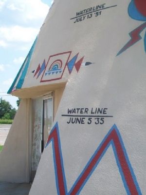
Photographed by William Fischer, Jr., August 2, 2014
1. Kansas River Flood Level Markers
July 13 '51
Water Line
June 5 '35
Topics. This historical marker is listed in these topic lists: Disasters • Waterways & Vessels. A significant historical month for this entry is June 1780.
Location. 39° 0.022′ N, 95° 13.875′ W. Marker is in Lawrence, Kansas, in Douglas County. It is on 1800th Road (U.S. 40) 0.1 miles east of U.S. 59, on the right when traveling east. Touch for map. Marker is at or near this postal address: "Teepee Junction", Lawrence KS 66044, United States of America. Touch for directions.

Regionally, this marker is in Eastern Kansas and specifically in Bleeding Kansas Border War Country. It is also in the American Midwest, in the Corn Belt, on the prairies, on the Southern Plains, and on the Santa Fe Trail Corridor. Globally, it is in North America, the Western Hemisphere, the Western World, and the Anglosphere. Historically, it finds itself in what was once the Louisiana Purchase.
Other nearby markers. At least 8 other markers are within 2 miles of this marker, measured as the crow flies: Lawrence Visitor Information Center (approx. 1½ miles away); The Douglas County Memorial of Honor
this page online
More about this marker. Flood levels are on the former Tee Pee Service Station.
Also see . . .
1. Historic Floods of Kansas. (Submitted on September 15, 2014, by William Fischer, Jr. of Reynoldsburg, Ohio.)
2. Kansas Emergency Relief Committee on 1935 Flood. (Submitted on September 15, 2014, by William Fischer, Jr. of Reynoldsburg, Ohio.)
3. Kansas Big Water - The Flood of 1951. (Submitted on September 15, 2014, by William Fischer, Jr. of Reynoldsburg, Ohio.)
4. Flood of 1951 at Kansapedia. (Submitted on September 15, 2014, by William Fischer, Jr. of Reynoldsburg, Ohio.)
5. Fifty-foot Tall Concrete Teepee. Roadside America website entry (Submitted on September 15, 2014, by William Fischer, Jr. of Reynoldsburg, Ohio.)
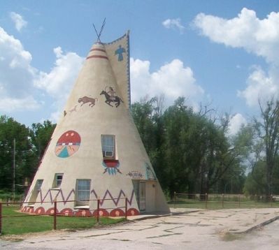
Photographed by William Fischer, Jr., August 2, 2014
2. Former Tee Pee Service Station
Credits. This page was last revised on January 12, 2025. It was originally submitted on September 15, 2014, by William Fischer, Jr. of Reynoldsburg, Ohio. This page has been viewed 788 times since then and 30 times this year. Photos: 1, 2. submitted on September 15, 2014, by William Fischer, Jr. of Reynoldsburg, Ohio.
