Salisbury in Essex County, Massachusetts — The American Northeast (New England)
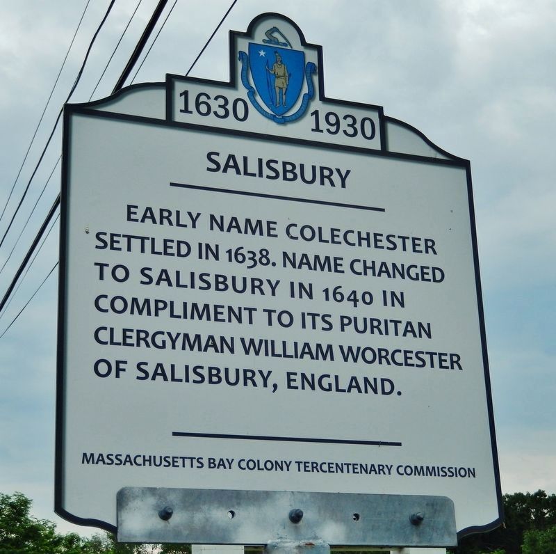
Salisbury
Early name Colchester settled in 1638. Name changed to Salisbury in 1640 in compliment to its Puritan clergyman William Worcester of Salisbury, England.
Erected 1930 by Massachusetts Bay Colony Tercentenary Commission.
Topics and series. This historical marker is listed in these topic lists: Colonial Era • Settlements & Settlers. In addition, it is included in the Massachusetts Bay Colony—Tercentenary Commission Markers series list. A significant historical year for this entry is 1638.
Location. 42° 52.417′ N, 70° 52.2′ W. Marker is in Salisbury, Massachusetts, in Essex County. Marker is on Lafayette Road (U.S. !) ¼ mile Pike Street (Massachusetts Route 286). Touch for map. Marker is at or near this postal address: 249 Lafayette Rd Salisbury, MA, Salisbury MA 01952, United States of America. Touch for directions.
Other nearby markers. At least 8 other markers are within 4 miles of this marker, measured as the crow flies. Essex Coastal Scenic Byway / Salisbury (approx. 0.8 miles away); Site of the Brown Library (approx. 1.4 miles away in New Hampshire); Shapley Line (approx. 1.6 miles away in New Hampshire); Robert Pike Homestead (approx. 2.3 miles away); First Meetinghouse (approx. 2.4 miles away); Amesbury Riverwalk (approx. 2.9 miles away); Bound Rock (approx. 3.1 miles away in New Hampshire); Macy-Colby House (approx. 3.6 miles away). Touch for a list and map of all markers in Salisbury.
Also see . . .
1. History of Salisbury, Massachusetts.
Salisbury, Massachusetts is the northernmost town in Massachusetts. Salisbury was once the home of the Pennacook tribe of Native Americans. It is estimated that anywhere between 3,000-12,000 Pennacook lived in the surrounding Merrimack Valley area where they used the Merrimack River as their primary mode of transportation. The Pennacook established many hunting trails in Salisbury, which the colonists later turned into roads, such as Ferry Road, Seabrook Road and Elm Street. (Submitted on March 25, 2018, by Cosmos Mariner of Cape Canaveral, Florida.)
2. About Salisbury.
This town, bordered by the Merrimack River and the Atlantic Ocean, originally named Colchester, was incorporated as Salisbury in 1640. Salisbury grew over time based on upland farms, salt marsh estuaries, building boats along the river, and its position on a major overland trade route to the north. When railroads were introduced, the line followed earlier routes from Newburyport heading to Portsmouth, aided by the low, gentle landscape that generally lacks steep hillsides or rocky terrain. (Submitted on March 25, 2018, by Cosmos Mariner of Cape Canaveral, Florida.)
Credits. This page was last revised on March 26, 2018. It was originally submitted on September 17, 2014, by David Remington of Rockport, Massachusetts. This page has been viewed 556 times since then and 22 times this year. Photos: 1. submitted on March 25, 2018, by Cosmos Mariner of Cape Canaveral, Florida. 2. submitted on September 17, 2014, by David Remington of Rockport, Massachusetts. • Bill Pfingsten was the editor who published this page.

