Halifax in Halifax Region, Nova Scotia — The Atlantic Provinces (North America)
Georges Island
L’Île-Georges

Photographed By Barry Swackhamer, June 14, 2014
1. Georges Island Marker
Click on image to enlarge.
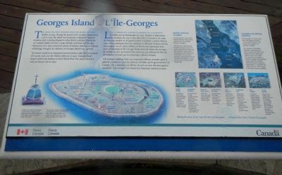
Captions: (lower left, English/French) To learn more about the Acadians imprisoned on Georges Island please go to the nearby monument to you right, about a hundred metres from here./Pour de plus amples renseignements sur l’emprisonnement des Acadiens dans l’île Georges, veuillez vous rendre au monument situé à votre droite, à quelque cent mètres d’ici.; (photographs at the upper right, English/French) Halifax Defence Complex Georges Island is one of five national sites known collectively as the Halifax Defence Complex. The five sites, administered by Parks Canada as part of a nation-wide family of historic sites, preserve and present a cross-section of the defences the British and Canadian militaries erected between the founding of Halifax and the end of the Second World War./Complexe de défense d’Halifax L’île-Georges est l’un des cinq lieux historique nationaux connus collectivement sous le nom de Complexe de défense d’Halifax. Les cinq lieux historiques nationaux administrés par Parcs Canada font partie d’une famille de lieux historiques répartis dans tout le pays. Ces cinq lieux protègent et mettent en valeur un échantillon représentatif des défenses construites par les militaires britannique et canadiens du milieu de XVIIIᵉ siècle jusqu’á la Seconde Guerre mondiale.; (bottom row, left to right, English/French) Halifax Citadel Completed in 1856, the fort protected Halifax from a possible landward attack; like all the defenses, underwent many artillery changes,/La Citadelle d’Halifax Le fort terminé en 1856, protégeait Halifax contre toute attaque terrestre éventuelle; l’artillerie de la Citadelle a connu de nombreux changements, comme toutes les autres défenses.; Prince of Wales Tower Built in the 1790s; one of the earliest Martello Towers in the British Empire./La Tour-Prince-de-Galles Construite dans les années 1790; une des premières tours Martello de l’empire britannique.; York Redoubt Fortification features from the 1790s to the Second World War; artillery collection spans several centuries./La Redoute-York Éléments de fortifications datant des années 1790 jusqu’à la Seconde Guerre mondiale; collection de pièces d’artillerie couvrant plusieurs siècles.; Fort McNab First fort in Halifax to have breech-loading artillery; played a key role in the defence of the outer harbour during the First and Second World Wars./ Le Fort-McNab Premier fort a Halifax à être équipé de cannons se chargeant par la culasse; a joué un rôle déterminant dans la défense de l’avant-port pendant la Première et la Seconde Guerre mondiale.
Captions: (lower left, English/French) To learn more about the Acadians imprisoned on Georges Island please go to the nearby monument to you right, about a hundred metres from here./Pour de plus amples renseignements sur l’emprisonnement des Acadiens dans l’île Georges, veuillez vous rendre au monument situé à votre droite, à quelque cent mètres d’ici.; (photographs at the upper right, English/French) Halifax Defence Complex Georges Island is one of five national sites known collectively as the Halifax Defence Complex. The five sites, administered by Parks Canada as part of a nation-wide family of historic sites, preserve and present a cross-section of the defences the British and Canadian militaries erected between the founding of Halifax and the end of the Second World War./Complexe de défense d’Halifax L’île-Georges est l’un des cinq lieux historique nationaux connus collectivement sous le nom de Complexe de défense d’Halifax. Les cinq lieux historiques nationaux administrés par Parcs Canada font partie d’une famille de lieux historiques répartis dans tout le pays. Ces cinq lieux protègent et mettent en valeur un échantillon représentatif des défenses construites par les militaires britannique et canadiens du milieu de XVIIIᵉ siècle jusqu’á la Seconde Guerre mondiale.; (bottom row, left to right, English/French) Halifax Citadel Completed in 1856, the fort protected Halifax from a possible landward attack; like all the defenses, underwent many artillery changes,/La Citadelle d’Halifax Le fort terminé en 1856, protégeait Halifax contre toute attaque terrestre éventuelle; l’artillerie de la Citadelle a connu de nombreux changements, comme toutes les autres défenses.; Prince of Wales Tower Built in the 1790s; one of the earliest Martello Towers in the British Empire./La Tour-Prince-de-Galles Construite dans les années 1790; une des premières tours Martello de l’empire britannique.; York Redoubt Fortification features from the 1790s to the Second World War; artillery collection spans several centuries./La Redoute-York Éléments de fortifications datant des années 1790 jusqu’à la Seconde Guerre mondiale; collection de pièces d’artillerie couvrant plusieurs siècles.; Fort McNab First fort in Halifax to have breech-loading artillery; played a key role in the defence of the outer harbour during the First and Second World Wars./ Le Fort-McNab Premier fort a Halifax à être équipé de cannons se chargeant par la culasse; a joué un rôle déterminant dans la défense de l’avant-port pendant la Première et la Seconde Guerre mondiale.
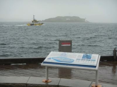
The Island was first fortified when the British founded Halifax in 1749. During the period of the Acadian Deportation, 1755 to 1762, the island was sometimes a detention camp for Acadians prior to being shipped to other British colonies. During the 19th century Halifax became a major British naval base and Georges Island one of an inter-connected system of harbour defences. As military technology changed, the defences of Georges Island were updated.
The island remained an important seaward defence after the Government of Canada took over the Halifax defences in 1906. Georges Island helped defend the harbour in both World Wars. The island became a national historic site in 1965.
French
L’île a d’abord été fortifiée au moment de la fondation d’Halifax par les Britanniques en 1749. Pendant le déportation des Acadiens, de 1755 à 1763, elle a servi, à l’occasion, de camp de détention pénible où un grand nombre d’Acadiens y étaient détenus avant d’être embarques dans des vaisseaux en direction d’autres colonies britanniques. Au XIXᵉ siècle, Halifax est devenu une importante base navale britannique et l’île Georges faisait partie du réseau des ouvrages de défense du port qui étaient reliés entre eux. Les défenses de l’île ont été adaptées à mesure que la technologie militaire évoluait.
L’île Georges continua d’être une importante défense maritime après la prise de contrôle en 1906 des défenses d’Halifax par le gouvernement du Canada. L’ile a contribué à la defense du port au cours des deux guerres mondiales. L’île Georges a été classée lieu historique national en 1965.
Erected by Parks Canada.
Topics. This historical marker is listed in this topic list: Forts and Castles. A significant historical year for this entry is 1749.
Location. 44° 38.67′ N, 63° 34.094′ W. Marker is in Halifax, Nova Scotia, in Halifax Region. Marker can be reached from Lower Water Street. Touch for map. Marker is in this post office area: Halifax NS B3J, Canada. Touch for directions.
Other nearby markers. At least 8 other markers are within walking distance of this marker. Pier 21 (within shouting distance of this marker); France and Canada (within shouting distance of this marker); Rotary Performance Platform & Lookoff/ Scéne et belvédère des clubs Rotary (within shouting distance of this marker); The Grand Dérangement (about 150 meters away, measured in a direct line); There Was Once a Very Special Ship (about 180 meters away); The Tall Ships Parade 2000 (about 180 meters away); Lebanese Immigrants (approx. 0.3 kilometers away); Black-Binney House (approx. 0.3 kilometers away). Touch for a list and map of all markers in Halifax.
More about this marker. This marker is located
on the Halifax waterfront, north of Bishop's Landing.
Also see . . . Georges Island (Nova Scotia) - Wikipedia. Georges Island (named after George II of Great Britain) is a glacial drumlin and the largest island entirely within the harbour limits of Halifax Harbour located in Nova Scotia's Halifax Regional Municipality. The Island is the location of Fort Charlotte - named after King George's wife Charlotte. 'Fort Charlotte was built during Father Le Loutre's War, a year after Citadel Hill (Fort George). The island is now a National Historic Site of Canada. (Submitted on October 1, 2014, by Barry Swackhamer of Brentwood, California.)
Credits. This page was last revised on June 16, 2016. It was originally submitted on October 1, 2014, by Barry Swackhamer of Brentwood, California. This page has been viewed 461 times since then and 16 times this year. Photos: 1, 2, 3. submitted on October 1, 2014, by Barry Swackhamer of Brentwood, California. • Andrew Ruppenstein was the editor who published this page.

