Reno's Beginning
Lake's Crossing and the Riverside Hotel
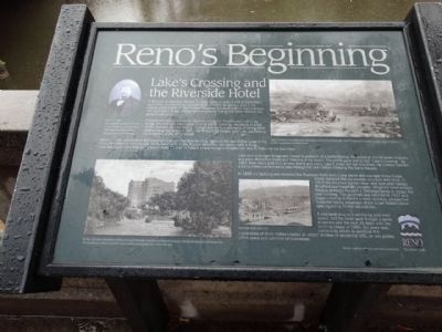
A Missouri mulepacker, William C. Fuller failed to strike it rich in California’s gold fields. His trek home, around 1859 or 1860, included a stop in the marshy valley known as the Truckee Meadows, located north of the Comstock Mining District, it was obvious that the pioneer trail to the Sierra Nevada was going to get busy.
Fuller found the highest piece of ground along the Truckee and built a log bridge near this site. He charged a small toil for crossing. He also built a log shelter that was popular among the tired and dusty prospectors. A spring flood washed away the bridge in 1861. He rebuilt the bridge, but Fuller was looking for a way out of the toll business.
Myron C. Lake, was another disillusioned miner who decided ranching might be the real Mother Lode of the West. He settled on a ranch near Honey Lake north of the Truckee Meadows, but barely made a living. Lake saw much more than just a way to cross the river on Fuller’s rickety bridge and traded his land to Fuller for the franchise.
Lake built a stronger bridge and moved it upstream to a better footing. He added an inn for weary travelers and even offered hot meals and libations at his tavern. The profits grew and so did “Lake Crossing.” By 1862 there was a grist mill, a livery stable and a kiln. Lake’s vision did not stop there. He lobbied
hard for a transcontinental railroad to pass through his town before climbing the Sierra Nevada.In 1888 the building was renamed the Riverside Hotel with a new owner and manager Harry Gosse. Gosse replaced the old wooden structure with brick. In 1922 the structure burned down and soon after George Wingfield purchased the property. Wingfield hired notable Nevada architect Frederic J. Delongchamps to design the new building. The landmark was finished in 1927 and began catering to Reno’s newest clientele, prospective divorcees taking advantage of the Silver State’s liberal laws regarding marital separations.
A new west wing and swimming pool were added, and the hotel went through a series of owners over the next 36 years until the building closed in 1986. Ten years later, community efforts to revitalize this cornerstone of Reno history created an artist’ enclave of residential lofts, an arts gallery, office space and commercial business.
Erected by Reno, The River Trail.
Topics. This historical marker is listed in these topic lists: Bridges & Viaducts • Industry & Commerce • Settlements & Settlers • Waterways & Vessels. A significant historical year for this entry is 1859.
Location. 39° 31.502′ N, 119° 48.86′ W. Marker is in Reno, Nevada, in Washoe County. Marker
Other nearby markers. At least 8 other markers are within walking distance of this marker. The Truckee River (about 300 feet away, measured in a direct line); The Virginia Street Bridges (about 400 feet away); Ginsburg Jewelry Company (about 500 feet away); Lake's Crossing (about 500 feet away); Site of Nevada’s First Public Library (about 600 feet away); Frederick Joseph DeLongechamps (about 600 feet away); Votes for Women (about 700 feet away); Reno (about 700 feet away). Touch for a list and map of all markers in Reno.
Credits. This page was last revised on December 20, 2020. It was originally submitted on October 2, 2014, by Denise Boose of Tehachapi, California. This page has been viewed 672 times since then and 19 times this year. Photos: 1, 2, 3, 4, 5, 6, 7. submitted on October 2, 2014, by Denise Boose of Tehachapi, California. • Syd Whittle was the editor who published this page.
