Cambridge in Dorchester County, Maryland — The American Northeast (Mid-Atlantic)
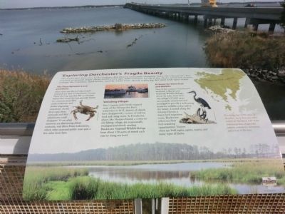
Exploring Dorchester's Fragile Beauty
The landscapes here may look timeless—but they’re constantly changing. Since the Chesapeake Bay reached its present shape about 4,000 years ago, tides continue to tug at the shore, wind and storms, reshape the coastline, land settles, and the water rises, slowly replacing dry land with open water.
The Place Between Land and Water
More than one third of Maryland’s wetlands are here in Dorchester County. These thriving marshes filter pollutants before they reach the bay, provide homes for creatures from blue crabs to herons, and shelter migrating waterfowl. As sea level rises, these wetlands and their inhabitants could disappear. To see what scientists are discovering about wetlands, visit Horn Point Laboratory, which offers seasonal public tours just a few miles from here.
Vanishing Villages
Since Captain John Smith mapped some of the Chesapeake Bay’s waterways in 1612, dozens of islands have disappeared—victims of sinking land and rising water. In Dorchester, places like Hoopers Island, a centuries-old fishing village, are occasionally swamped and slowly eroding. Blackwater National Wildlife Refuge loses about 130 acres of marsh each year to rising sea level.
A Haven for Waterfowl and Wildlife
One of the country’s best-known wetlands is Blackwater National Wildlife Refuge, about 12 miles from here. The refuge’s 27,000 acres are carefully monitored and managed to provide a welcoming home for wildlife today and in the future. Located along the Atlantic Flyway, a major bird migration route, Blackwater offers excellent bird-watching opportunities. Visitors often spy bald eagles, egrets, osprey, and many types of ducks.
[Caption:]
Dorchester County has 1,700 miles of shoreline, more than any other county in Maryland. Our many waterways have shaped the culture, commerce, recreation, and a way of life here.
Erected by Maryland Heritage Area.
Topics. This historical marker is listed in these topic lists: Animals • Environment • Horticulture & Forestry • Waterways & Vessels. A significant historical year for this entry is 1612.
Location. 38° 34.302′ N, 76° 3.834′ W. Marker is in Cambridge, Maryland, in Dorchester County. Marker is on Rose Hill Place. The marker is located on the back porch of the Dorchester County Visitor Center. Touch for map. Marker is at or near this postal address: 2 Rose Hill Place, Cambridge MD 21613, United States of America. Touch for directions.
Other nearby markers. At least 8 other markers are within walking distance of this marker. The Dorchester Waterman (within shouting distance of this marker); Living off the Land (within shouting distance of this marker); A Landscape and Lifestyle Defined by Water (within shouting distance of this marker); Choptank River's Natural History (within shouting distance of this marker); Choptank River Bridge (within shouting distance of this marker); Maryland's Eastern Shore (within shouting distance of this marker); Discover: Dorchester (within shouting distance of this marker); Enjoy Our Park (within shouting distance of this marker). Touch for a list and map of all markers in Cambridge.
Credits. This page was last revised on August 28, 2022. It was originally submitted on November 8, 2014, by Don Morfe of Baltimore, Maryland. This page has been viewed 316 times since then and 8 times this year. Photos: 1, 2. submitted on November 8, 2014, by Don Morfe of Baltimore, Maryland. • Bill Pfingsten was the editor who published this page.

