Young in Gila County, Arizona — The American Mountains (Southwest)
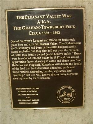
The Pleasant Valley War a.k.a. The Graham-Tewksbury Feud
Circa 1882 - 1892
Inscription.
One of the West’s Longest and Bloodiest feuds took place here and around Pleasant Valley. The Grahams and the Tewksburys had been in the cattle business and it seems probable that they first fell out over the division of cattle they jointly owned (some believe stole). “Sheep were introduced into the valley in 1887 and this was an aggravating factor, drawing in cattle and sheep men from Holbrook and Flagstaff. Historians still debate the details of the feud that included brand changing, cattle and horse rustling, ambushes, murder, vigilantes, and lynching.” But it is well known that as many as twenty men lay dead by its conclusion.
Erected 2008 by Lost Dutchman 5917+4, E Clampus Vitus and the Pleasant Valley Historical Society.
Topics and series. This historical marker is listed in these topic lists: Landmarks • Notable Events. In addition, it is included in the E Clampus Vitus series list. A significant historical year for this entry is 1887.
Location. 34° 6.106′ N, 110° 56.371′ W. Marker is in Young, Arizona, in Gila County. Marker is on Desert to Tall Pines Highway / Young Highway Road (State Highway 288). Marker is located in front of the Young Museum. Touch for map. Marker is in this post office area: Young AZ 85554, United States of America. Touch for directions.
More about this marker. Young, Arizona can be reached by driving south from Highway 260 for 25 miles or by driving north 66 miles from Globe, Arizona.
Also see . . . Arizona’s Pleasant Valley War. Legends of America website entry (Submitted on July 21, 2021, by Larry Gertner of New York, New York.)
Credits. This page was last revised on July 21, 2021. It was originally submitted on October 15, 2011, by Frank Houdek of Kingman, Arizona. This page has been viewed 2,107 times since then and 165 times this year. Last updated on November 9, 2014, by Kevin Craft of Bedford, Quebec. Photo 1. submitted on October 15, 2011, by Frank Houdek of Kingman, Arizona. • Syd Whittle was the editor who published this page.
Editor’s want-list for this marker. A photo of the marker and the surrounding area in context. • Can you help?
