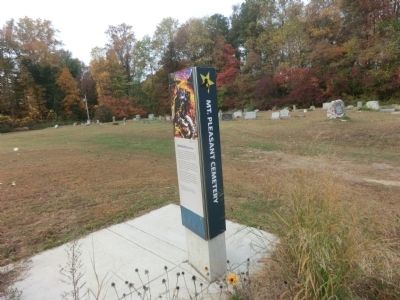
Mt. Pleasant Cemetery
Dangerous Rendezvous
— Harriet Tubman Underground Railroad Byway —
After Quakers sold their meetinghouse to the local black community in 1849, the new owners established Mt. Pleasant Methodist Episcopal Church. The original church building has since burned, but the modern day congregation still uses the cemetery.
Laws restricted blacks from meeting in groups and a group of slaves gathering in a home or in the woods might arouse suspicion. But they did gather at cemeteries---a rare respite amidst the constant oversight that prevailed in the 19th century slave societies.
One escapee testified that Harriet Tubman used a cemetery for a nighttime rendezvous away from the suspicious eyes of plantation masters and overseers. This evidence suggests that some freedom seekers took their first secretive step on the Underground Railroad surrounded by silent ancestors.
Above: In 1857, Tubman raced to the area to rescue her free parents, Ben and Rit Ross, who lived nearby. Ben was about to be arrested for helping the “Dover Eight,” a group of freedom seekers who had fled Dorchester County.
Topics and series. This historical marker is listed in these topic lists: Abolition & Underground RR • African Americans. In addition, it is included in the Harriet Tubman Underground Railroad Byway, and the Quakerism series lists. A significant historical year for this entry is 1849.
Location.
Other nearby markers. At least 8 other markers are within 3 miles of this marker, measured as the crow flies. Mt. Pleasant M. E. Church (a few steps from this marker); Site of Frazier’s Chapel (approx. 1.1 miles away); Preston (approx. 1.1 miles away); Linchester Mill (approx. 2 miles away); The Underground Railroad (approx. 2 miles away); Linchester (approx. 2 miles away); a different marker also named Linchester Mill (approx. 2.1 miles away); Leverton House (approx. 2.2 miles away). Touch for a list and map of all markers in Preston.
![Mt. Pleasant Cemetery Marker [Reverse]. Click for full size. Mt. Pleasant Cemetery Marker [Reverse] image. Click for full size.](Photos6/676/Photo676664.jpg?952022125800PM)
Credits. This page was last revised on September 5, 2022. It was originally submitted on November 26, 2014, by Don Morfe of Baltimore, Maryland. This page has been viewed 790 times since then and 36 times this year. Photos: 1. submitted on February 7, 2018, by Allen C. Browne of Silver Spring, Maryland. 2. submitted on September 5, 2022, by Devry Becker Jones of Washington, District of Columbia. 3. submitted on November 26, 2014, by Don Morfe of Baltimore, Maryland. • Bill Pfingsten was the editor who published this page.

