Salisbury in Wicomico County, Maryland — The American Northeast (Mid-Atlantic)
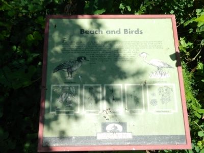
Beach and Birds
Photographed by Nate Davidson, July 25, 2014
1. Beach and Birds Marker
Along the bank of the beach you can see several of the plants you have learned about today. Also, you may see wild rose with its simple flower or its rose-hip fruit. You may also see several grasses , sedges, water hemlock and rushes around the area. An interesting plant to look for is the Jewelweed, so called due to the way dew and rain bead up on its leaves and form bright rainbow-colored "jewels."
Erected by Chesapeake Bay Gateways Network.
Topics. This historical marker is listed in this topic list: Environment.
Location. 38° 21.083′ N, 75° 34.267′ W.
this page online

Regionally, this marker is on the Eastern Shore. It is also in the American Mid-Atlantic, on the Delmarva Peninsula, in the Tidewater, and on the Eastern Seaboard. Globally, it is in the North Atlantic Region, North America, the Western Hemisphere, the Western World, and the Anglosphere. Historically, it finds itself in what was once one of the original Thirteen Colonies and also the Antebellum South.
Other nearby markers. At least 8 other markers are within walking distance of this marker: Wildfowl Blind (within shouting distance of this marker); Dry Thickets (within shouting distance of this marker); Open Pond (within shouting distance of this marker); Fruited Trees and Vines (within shouting distance of this marker); Welcome (within shouting distance of this marker); Wooded Wetland (about 400 feet away, measured in a direct line); Waterside (about 400 feet away); Wetland Marsh
Photographed by Nate Davidson, July 25, 2014
2. Beach and Birds Marker
Credits. This page was last revised on June 16, 2016. It was originally submitted on November 27, 2014, by Nathan Davidson of Salisbury, Maryland. This page has been viewed 416 times since then and 16 times this year. Photos: 1, 2. submitted on November 27, 2014, by Nathan Davidson of Salisbury, Maryland. • Bill Pfingsten was the editor who published this page.
