St. Joseph in Buchanan County, Missouri — The American Midwest (Upper Plains)
A Path To Freedom
Finding refuge across the river
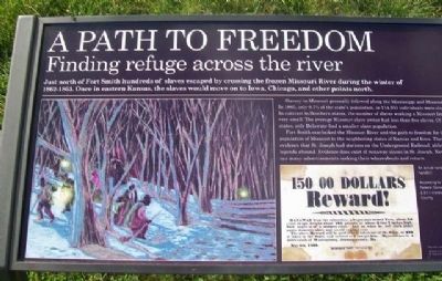
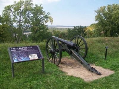
Just south of Fort Smith hundreds of slaves escaped by crossing the frozen Missouri River during the winter of 1862-1863. Once in eastern Kansas, the slaves would move on to Iowa, Chicago, and other points north.
Slavery in Missouri generally followed along the Mississippi and Missouri Rivers. In 1860, only 9.7% of the state's population, or 114,931 individuals were slaves. In contrast to Southern states, the number of slaves working a Missouri farm was very small. The average Missouri slave owner had less than five slaves. Of the slave states, only Delaware had a smaller slave population.
Fort Smith overlooked the Missouri River and the path to freedom for the enslaved population of Missouri to the neighboring states of Kansas and Iowa. There is no evidence that St. Joseph had stations on the Underground Railroad, although local legends abound. Evidence does exist of runaway slaves in St. Joseph. Newspapers ran many advertisements seeking their whereabouts and return.
[Inset illustration captions read]
An actual runaway slave handbill.
According to the 1860 Federal Census, there were 2,011 slaves in Buchanan County.
Erected 2014 by Missouri Humanities Council and Many Other Donors.
Topics. This historical marker is listed in these topic lists: Abolition & Underground RR • African Americans • Waterways & Vessels. A significant historical year for this entry is 1860.
Location. 39° 46.363′ N, 94° 51.786′ W. Marker is in St. Joseph, Missouri, in Buchanan County. Marker is in Fort Smith Park, on Prospect Hill, accessed from Bellevue and Michel Streets. Touch for map. Marker is in this post office area: Saint Joseph MO 64501, United States of America. Touch for directions.
Other nearby markers. At least 8 other markers are within walking distance of this marker. St. Joseph (within shouting distance of this marker); Fort Smith (within shouting distance of this marker); The Men of the Corps of Discovery / The Lewis and Clark Expedition (approx. 0.4 miles away); Pony Express (approx. half a mile away); Joseph Robidoux (approx. half a mile away); The California - Oregon Trail (approx. half a mile away); St. Michael's Prairie / The Lewis and Clark Expedition (approx. half a mile away); Buchanan County Courthouse (approx. half a mile away). Touch for a list and map of all markers in St. Joseph.
Also see . . .
1. National Underground Railroad Network to Freedom. National Park Service website entry (Submitted on November 30, 2014, by William Fischer, Jr. of Scranton, Pennsylvania.)
2. Slavery on the Western Border: Missouri's Slave System and its Collapse during the Civil War. Civil War on the Western Border website entry (Submitted on November 30, 2014, by William Fischer, Jr. of Scranton, Pennsylvania.)
3. Seeking the Promised Land: African American Migrations to Kansas. Civil War on the Western Border website entry (Submitted on November 30, 2014, by William Fischer, Jr. of Scranton, Pennsylvania.)
Credits. This page was last revised on May 27, 2022. It was originally submitted on November 30, 2014, by William Fischer, Jr. of Scranton, Pennsylvania. This page has been viewed 716 times since then and 31 times this year. Photos: 1, 2, 3, 4. submitted on November 30, 2014, by William Fischer, Jr. of Scranton, Pennsylvania.
Editor’s want-list for this marker. Full close photo of marker • Can you help?


