Near Mitchell in Scotts Bluff County, Nebraska — The American Midwest (Upper Plains)
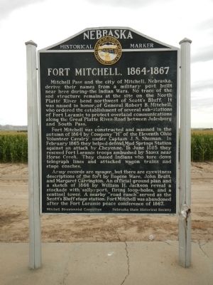
Fort Mitchell, 1864-1867
Fort Mitchell was constructed and manned in the autumn of 1864 by Company “H” of the Eleventh Ohio Volunteer Cavalry under Captain J.S. Shuman. In February 1865 they helped defend Mud Springs Station against an attack by Cheyenne. In June 1865 they rescued Fort Laramie troops ambushed by Sioux near Horse Creek. They chased Indians who tore down telegraph lines and attacked wagon trains and stage coaches.
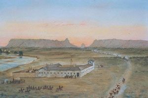
Army records are meager, but there are eyewitness descriptions of the fort by Eugene Ware, John Bratt, and Margaret Carrington. An official ground plan and a sketch of 1866 by William H. Jackson reveal a stockade with sally-port, firing loop-holes, and a sentinel tower. A nearby “road ranch” served as the Scott’s Bluff stage station. Fort Mitchell was abandoned after the Fort Laramie peace conference of 1867.
Erected by Mitchell Bicentennial Committee & Nebraska State Historical Society. (Marker Number 190.)
Topics and series. This historical marker is listed in these topic lists: Forts and Castles • Wars, US Indian. In addition, it is included in the Nebraska State Historical Society series list. A significant historical month for this entry is February 1865.
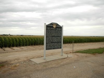
Location. 41° 51.441′ N, 103° 44.146′ W. Marker is near Mitchell, Nebraska, in Scotts Bluff County. Marker is on Old Oregon Trail Road near Nebraska Highway 92, on the left when traveling north. Touch for map. Marker is at or near this postal address: 173462 Old Oregon Trail Road, Mitchell NE 69357, United States of America. Touch for directions.
Other nearby markers. At least 8 other markers are within 3 miles of this marker, measured as the crow flies. A different marker also named Fort Mitchell, 1864-1867 (approx. 0.7 miles away); Scott's Bluff Pony Express Station (approx. ¾ mile away); Assistance on the Trail (approx. 2.1 miles away); History Lives on in Art (approx. 2.1 miles away); Oregon Trail (approx. 2.1 miles away); Saddle Club, Inc. (approx. 2.2 miles away); The Way West (approx. 2.2 miles away); The River Route (approx. 2.2 miles away). Touch for a list and map of all markers in Mitchell.
Also see . . . Nebraska Forts - Page 2 - Legends of America. The outbreak of the Civil War in 1861 stretched the Federal Government’s resources for the West thin, making it increasingly difficult for the government to protect emigrants and other travelers on overland trails. Many U.S. soldiers went back East to fight for the Union, which weakened the frontier garrisons. (Submitted on December 6, 2014, by Barry Swackhamer of Brentwood, California.)

Photographed By Barry Swackhamer, August 22, 2014
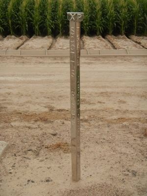
3. Scott's Bluff Pony Express Station stake
located to the right of the Fort Mitchell marker.
XP / Scott’s Bluff / Station site / Pony Express / Trail 1860-1861
Dedicated August 2005, Rededicated June 2014
Site located: True azimuth 39 degrees and 3,206 feet
Sponsored by: Gregory & Kathy Franz - Jim Stretesky
Panhandle Monuments - Joe & Lois Fairfield
Pony Express Trail Association - Joe Nardone, Historian
Dedicated August 2005, Rededicated June 2014
Site located: True azimuth 39 degrees and 3,206 feet
Sponsored by: Gregory & Kathy Franz - Jim Stretesky
Panhandle Monuments - Joe & Lois Fairfield
Pony Express Trail Association - Joe Nardone, Historian
Credits. This page was last revised on June 16, 2016. It was originally submitted on December 6, 2014, by Barry Swackhamer of Brentwood, California. This page has been viewed 561 times since then and 14 times this year. Photos: 1, 2, 3, 4. submitted on December 6, 2014, by Barry Swackhamer of Brentwood, California. • Bill Pfingsten was the editor who published this page.


