Near Guernsey in Platte County, Wyoming — The American West (Mountains)
Register Cliff State Historic Site
Photographed by Barry Swackhamer, August 23, 2014
1. Register Cliff State Historic Site Marker
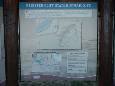
West of Register Cliff the landscape changes, presenting new challenges for the emigrants. Limited water and rugged terrain made travel more difficult as they journeyed across the plains of southern Wyoming toward Fort Bridger, the next major supply point - 368 miles away.
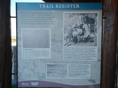
Register Cliff represents one of the best ‘trail registers in the desert’. Countless emigrants inscribed their names, dates, places of origin, and messages into the sandstone cliffs. The earliest inscriptions date back to the fur traders and trappers who passed through this region in the early 1800’s.
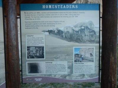
In the 1870s and 1880s, ranchers and homesteaders moved into this area. Charles A. Guernsey, for whom the town of Guernsey is named, came here in June of 1880, trailing cattle from Colorado. The Guernsey Cattle Company was established the following year with “999” (Three-Nine) as its brand.
Guernsey established his ranch at the base of Register Cliff and continued to operate
this page online
Erected by Wyoming State Parks & Cultural Resources.
Topics and series. This historical marker is listed in these topic lists: Roads & Vehicles • Settlements & Settlers. In addition, it is included in the Oregon Trail series list. A significant historical month for this entry is June 1880.
Location. 42° 14.871′ N, 104° 42.681′ W. Marker is near Guernsey, Wyoming, in Platte County. It is on unnamed road near South Guernsey Road. Touch for map. Marker is in this post office area: Guernsey WY 82214, United States of America. Touch for directions.

Regionally, this marker is in Wyoming’s Laramie Basin and in the Westward Expansion Trails Region. It is also in the American Mountain West, on the Great Plains, and specifically on the High Plains. Globally, it is in North America, the Western Hemisphere, the Western World, and the Anglosphere. Historically, it finds itself in what was once the Louisiana Purchase.
Other nearby markers. At least 8 other markers are within 2 miles of this marker, measured as the
Photographed by Barry Swackhamer, August 23, 2014
2. Trail Register Marker
Captions: (left) Carved in Stone The names and dates at Register Cliff reflect the peak years of travel along the Oregon Trail during the 1840s and 1850s. Several states are represented in the carvings - Ohio being the most common.; (right) Register Cliff, also known as ‘Sand Draw’, was the first camp west of Fort Laramie. Beside these sandstone cliffs near the North Platte River, emigrants stopped to set up camp, pasture their animals, and rest from the hardships of trail life. Its is common to see cemeteries at river crossings along the trail. The crossings themselves were dangerous. The graves of several unknown emigrants are in the cemetery here at Register Cliff.; (bottom) Young Alvah H. Unthank, 19 years old and bound for the California gold fields, left his mark here in 1850. Alvah never made it to California. Like thousands of other emigrants, he succumbed to cholera, a disease spread by unsanitary conditions along the trail.
More about this marker. These panels are located at the Register Cliffs kiosk.
Photographed by Barry Swackhamer, August 23, 2014
3. Homesteaders Marker
Captions: (center left) Trading Post In the mid-1850s, a small trading post just west of the cliffs provided supplies to emigrants traveling west. Later, a pony express station, known as Sand Point or Star Ranch Station, was based here.; (bottom left) Cold Storage A root cellar for storage of produce was essential before the days of supermarkets. The Frederick family blasted an opening into the cliff face for storing potatoes and other vegetables. The constant temperatures kept produce cool in the summer and protected it from freezing in the winter.; (bottom right) A Gift to the State Henry Frederick gifted Register Cliff to the State of Wyoming in 1932. It is through the generosity of the Frederick family that the site is open to the public. In 1970, the site was listed on the National Register of Historic Places.
Photographed by Barry Swackhamer, August 23, 2014
4. Register Cliff State Historic Site Marker
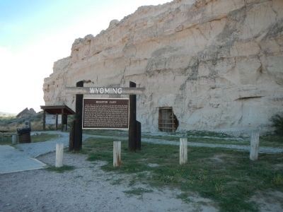
The kiosk is located to the left of the large Register Cliff marker. Note the Frederick's root cellar to the right, now boarded over.
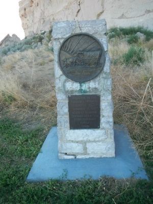
Photographed by Barry Swackhamer, August 23, 2014
5. Register Cliff dedication monument
pioneers of Wyoming
Register Cliff
acquired by the
State of Wyoming
through gift of the
Henry Frederick
family
1932
Credits. This page was last revised on June 16, 2016. It was originally submitted on December 22, 2014, by Barry Swackhamer of Brentwood, California. This page has been viewed 1,102 times since then and 49 times this year. Photos: 1, 2, 3, 4, 5. submitted on December 22, 2014, by Barry Swackhamer of Brentwood, California. • Andrew Ruppenstein was the editor who published this page.
