The Town of Herrington: Unearthing the Origins of South County
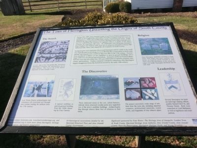
Archaeologists and volunteers discovered Herrington about a mile to the south on a high flat area overlooking a cove on Herring Bay, in proximity to fresh water springs and aligned with a roadway that may date to the 17th century. Excavations produced evidence of two earthfast or post-in-ground buildings and a large collection of colonial period artifacts. Extensive archival research identified one-acre size lots within this 100-acre settlement occupied by planters, merchants, and mariners. Further research is needed to determine
this page online
The Search
(Inscription under the map in the upper left)
A 1671 map of the Chesapeake Bay documents Herrington’s existence, but, unfortunately, not its exact location. This view is one of the earliest depictions of Anne Arundel County.
(Inscription under the photo in the lower left)
Lost Towns Project archaeologists and volunteers sift excavated soil through wire screens looking for artifacts from the 17th century.
The Discoveries
(Inscription under the photo in the lower center)
These darkened stains in the soil, called features, indicate where structural wooden posts once supported one of the towns earthfast buildings. Archaeologist dug through almost three feet of siltation to find them.
(Inscription under the photo in the lower center right)
The project recovered a wide range of artifacts from the town site, including imported ceramics, architectural materials, oyster shells, and fragments of clay tobacco pipes.
Religion
(Inscription under the photo at the right top)
Some Herrington inhabitants converted to Quakerism, while others were active
Please contact losttowns.com, www.fourriversheritage.org. and annearundeltrust.org to learn more about Herrington, heritage area resources, and historic preservation. Archaeological excavations funded by the Maryland Historical Trust and Anne Arundel County Government.
Signboard sponsored by Four Rivers: The Heritage Area of Annapolis, London Town and South County, Maryland Heritage Areas Authority, Anne Arundel County, Anne Arundel County Trust for Preservation, Herrington Harbour North, and Severn Graphics.
Topics. This historical marker is listed in these topic lists: Colonial Era • Settlements & Settlers. A significant historical year for this entry is 1671.
Location. 38° 46.59′ N, 76° 34.032′ W. Marker is in Tracys Landing, Maryland, in

Regionally, this marker is in Central Maryland. It is also in the American Mid-Atlantic, in the Chesapeake Bay Region, and on the Eastern Seaboard. Globally, it is in the North Atlantic Region, North America, the Western Hemisphere, the Western World, and the Anglosphere. Historically, it finds itself in what was once one of the original Thirteen Colonies and also the Antebellum South.
Other nearby markers. At least 8 other markers are within 5 miles of this marker, measured as the crow flies: Birds of Prey (about 700 feet away, measured in a direct line); Outnumbered (about 800 feet away); Wildlife You May See (approx. 0.3 miles away); Chesapeake Bay Wetlands (approx. 0.3 miles away); Anne and Christopher Birckhead (approx. 1.9 miles away); Saint James’ Church (approx. 1.9 miles away); Holly Hill (approx. 3.3 miles away); Women of Hartge Yacht Yard (1934-2006) (approx. 4½ miles away).
Credits. This page was last revised on June 16, 2016. It was originally submitted on December 30, 2014, by Don Morfe of Baltimore, Maryland. This page has been viewed 1,338 times since then and 46 times this year. Photos: 1, 2, 3, 4, 5, 6, 7, 8. submitted on December 30, 2014, by Don Morfe of Baltimore, Maryland. • Bill Pfingsten was the editor who published this page.
