Near South Pass City in Fremont County, Wyoming — The American West (Mountains)
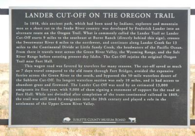
Lander Cut-Off on the Oregon Trail
This wagon road was favored by travelers for many reasons. The cut-off save as much as 7 days travel compared to the old route though Fort Bridger. avoided the expensive ferries across the Green River to the south, and bypassed the 50-mile waterless desert of the Sublette Cut-Off. Its longest waterless section was only 10 miles, and it had access to abundant grass and firewood. The Lander Cut-Off was used by an estimated 13,000 emigrants its first year, with 9,000 of them signing statements of support for the road at Fort Hall. While use dwindled after completion of the trans-continental railroad in 1869, the trail was still used by emigrants into the 20th century and played a role in the settlement of the Upper Green River Valley.
Erected by Sublette County Museum Board.
Topics and series. This historical marker is listed in these topic lists: Roads & Vehicles • Settlements & Settlers. In addition, it is included in the Oregon Trail series list. A significant historical year for this entry is 1858.
Location. 42° 25.374′ N, 108° 52.355′ W. Marker is near South Pass City, Wyoming, in Fremont County. Marker is on Dickinson Avenue (State Highway 28) near Lander Cut-Off Road, on the left when traveling south. Touch for map. Marker is in this post office area: Lander WY 82520, United States of America. Touch for directions.
Other nearby markers. At least 8 other markers are within 6 miles of this marker, measured as the crow flies. Meadows in the Sage (approx. 3.1 miles away); South Pass (approx. 3.1 miles away); How a Stamp Mill Works (approx. 4.6 miles away); Crushing Gold Ore (approx. 4.7 miles away); First Masonic Lodge in Wyoming (approx. 4.8 miles away); South Pass City (approx. 4.8 miles away); Esther Hobart Morris (approx. 4.9 miles away); South Pass City: Wyoming’s Biggest Gold Boom and Bust (approx. 5.3 miles away). Touch for a list and map of all markers in South Pass City.
Also see . . . The Lander Trail: National Road Building Comes to Wyoming - Wyoming State Historical Society. In 1857, with passage of the Pacific Wagon Road Act, Congress appropriated funds to survey and construct wagon roads. A segment of the first such national wagon road to be built in the West, now known as the Lander Trail, the Lander Road or Lander Cutoff, was named after the man in charge of its construction. (Submitted on January 7, 2015, by Barry Swackhamer of Brentwood, California.)
Credits. This page was last revised on June 16, 2016. It was originally submitted on January 7, 2015, by Barry Swackhamer of Brentwood, California. This page has been viewed 852 times since then and 51 times this year. Photos: 1, 2. submitted on January 7, 2015, by Barry Swackhamer of Brentwood, California. • Andrew Ruppenstein was the editor who published this page.

