Wahoo in Saunders County, Nebraska — The American Midwest (Upper Plains)
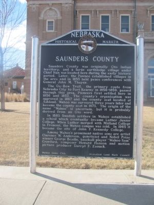
Saunders County
Photographed by Joan Shurtliff, January 19, 2015
1. Saunders County Marker
The Ox-Bow Trail, the primary route from Nebraska City to Fort Kearny in 1845-1859, passed through this area. Pioneers first settled here in 1856 and 1857. The county's organization was approved in 1867 and the county seat located at Ashland. Wahoo was surveyed three years later and became the county seat in 1873. The origin of the name "Wahoo" is uncertain, but it is probably derived from an Oto word.
In 1883 Swedish settlers in Wahoo established a school which eventually became Luther Junior College. When Luther merged with Midland College in Fremont, the Wahoo campus was sold. In 1965 it became the site of John F. Kennedy College.
Among Wahoo's prominent native sons are artist Clarence W. Anderson, geneticist and Nobel Prize winner George Beadle, baseball player "Wahoo Sam" Crawford, composer Howard Hanson and motion picture producer Darryl F. Zanuck.
Wahoo
this page online
Historical Land Mark Council
US 30 A & 77, Wahoo
Saunders County
Marker 82
Erected by Wahoo Lions Club; Historical Land Mark Council. (Marker Number 82.)
Topics and series. This historical marker is listed in these topic lists: Indigenous Peoples and Communities • Political Subdivisions • Settlements & Settlers. In addition, it is included in the Nebraska State Historical Society series list. A significant historical year for this entry is 1855.
Location. 41° 12.57′ N, 96° 37.37′ W. Marker is in Wahoo, Nebraska, in Saunders County. It is on North Chestnut Street (U.S. 30A&77) south of West 5th Street, on the right when traveling south. This marker is located southeast of the Saunders County Courthouse. Touch for map. Marker is at or near this postal address: 433 N Chestnut Street, Wahoo NE 68066, United States of America. Touch for directions.

Regionally, this marker is in Eastern Nebraska and in Greater Lincoln. It is also in the American Midwest, in the Corn Belt, and on the prairies. Globally, it is in North America, the Western Hemisphere, the Western World, and the Anglosphere. Historically,
Photographed by Joan Shurtliff, January 19, 2015
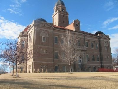
2. Saunders County Courthouse.
Other nearby markers. At least 6 other markers are within 15 miles of this marker, measured as the crow flies: USS Wahoo SS238 (a few steps from this marker); U.S.S. Wahoo SS 238 (a few steps from this marker); Atlas D Missile Site A-1 (approx. 7.4 miles away); a different marker also named Atlas D Missile Site A-1 (approx. 9.6 miles away); The Armour and Company Icehouse (approx. 12.4 miles away); Pawnee Villages (approx. 14½ miles away).
Credits. This page was last revised on December 22, 2024. It was originally submitted on January 21, 2015, by Joan Shurtliff of Seward, Nebraska. This page has been viewed 783 times since then and 35 times this year. Photos: 1, 2. submitted on January 21, 2015, by Joan Shurtliff of Seward, Nebraska. • Andrew Ruppenstein was the editor who published this page.
