Near Charlottesville in Albemarle County, Virginia — The American South (Mid-Atlantic)
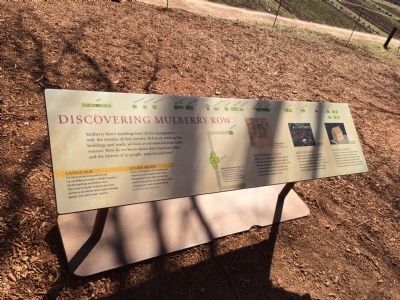
Discovering Mulberry Row
Mulberry Row’s buildings have all but disappeared—only the remains of four survive. Before re-creating lost buildings and roads, we look at information from many sources. How do we know about this important place and the history of its people, enslaved and free?
Language
For historical accuracy and context, we use Jefferson’s terms—noted in quotes—for the buildings on Mulberry Row. The word “enslaved” indicates that men, women and children were held in bondage against their will by their masters.
Learn more
We are in the process of re-creating and restoring some of Mulberry Row’s lost buildings and roads. What you will see unfold is the product of more than 50 years of study. Learn more and comment at monticello.org/mulberryrow.
Jefferson’s Clues
Jefferson’s record-keeping makes Monticello one of the best documented plantations anywhere. Historians study letters, maps, and account books to discover valuable information about who lived here, what they did, and how and why Mulberry Row changed over time.
Archaeology
Since the 1950s, archaeologists have located the foundations of the buildings on Jefferson’s Mutual Assurance plat, discovered more structures and unearthed thousands of artifacts. These artifacts provide evidence about how enslaved and free people lived and worked.
Digital Models
What did the buildings on Mulberry Row look like in Jefferson’s time? Architects and historians use archaeological evidence and knowledge of building techniques to create drawings and digital models of the lost buildings. These models will serve as a guide to re-creating dwellings, workshops and storehouses.
(captions)
(left to right): Jefferson’s Mutual Assurance plat, 1796. For insurance purposes, Jefferson sketched and described the Mulberry Row dwellings, storehouses, and workshops near his main house (A.) and what is now the South Pavilion (B.). Massachusetts Historical Society
Slave roll, Jefferson’s Farm Book, 1810. Massachusetts Historical Society
Excavation of slave dwellings r and s.
Digital model of slave dwelling s.
Topics. This historical marker is listed in these topic lists: African Americans • Colonial Era • Industry & Commerce. A significant historical year for this entry is 1796.
Location. 38° 0.564′ N, 78° 27.168′ W. Marker is near Charlottesville, Virginia, in Albemarle County. Marker can be reached from Monticello Loop north of Thomas Jefferson Parkway (Virginia Route 53), on the left when traveling north. Touch for map. Marker is at or near this postal address: 931 Thomas Jefferson Pkwy, Charlottesville VA 22902, United States of America. Touch for directions.
Other nearby markers. At least 8 other markers are within walking distance of this marker. Forge & Quarters (a few steps from this marker); The Levy Legacy (within shouting distance of this marker); Smokehouse/Dairy (within shouting distance of this marker); Nail-Making (within shouting distance of this marker); South Pavilion (within shouting distance of this marker); Making Monticello (within shouting distance of this marker); A Presidential Scandal: (within shouting distance of this marker); Sally Hemings's Life (within shouting distance of this marker). Touch for a list and map of all markers in Charlottesville.
Also see . . . Mulberry Row Reassessment. Thomas Jefferson's Monticello website entry (Submitted on January 17, 2023, by Larry Gertner of New York, New York.)
Credits. This page was last revised on February 2, 2023. It was originally submitted on February 15, 2015, by J. Makali Bruton of Accra, Ghana. This page has been viewed 632 times since then and 28 times this year. Photos: 1, 2. submitted on February 15, 2015, by J. Makali Bruton of Accra, Ghana. • Bernard Fisher was the editor who published this page.

