Indian Life at the Stearns Site
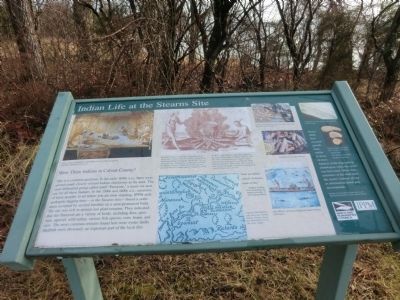
(Inscription below the image in the upper left)
Above: Artist’s rendering of an Indian Family in their longhouse. Top Right: Boiling food in pot.
Theodore De Bry created the engraving above based on a series of 28 drawing by John White depicting Indians during the late 1500s. The engraving were included in a publication written by
this page online
“Here are infinite schools of diverse kinds of fish.” William Strachey, 1612, describing the natural resources of the Patuxent River.
(Inscription beside the map in the center)
Captain John Smith’s map showing various Indian villages along the Patuxent River in the early 1600s.
(Inscription under the three images on the right)
1. Oyster shell filled trash pit, showing deer antler. Pit dates to the 1400s AD. 2. Varieties of corn after harvest. 3. John White’s drawing of different Indian fishing techniques,
(Inscription under the image in the far right)
Close-up of oyster shell hinge, showing growth rings.
Oyster shells have seasonal growth rings, similar to those on trees. Analysis of the rings tells archaeologists when the oyster was harvested.
Erected by Maryland Humanities Council and the Friends of JPPM.
Topics. This historical marker is listed in this topic list: Indigenous Peoples and Communities. A significant historical year for this entry is 1590.
Location. 38° 24.068′ N, 76° 30.78′ W. Marker is in St. Leonard, Maryland, in Calvert County. It is on Jefferson Patterson Park Road. The marker is on the grounds of the Jefferson Patterson Park and Museum. Touch for map. Marker is in this post office area: Saint Leonard MD 20685, United States of America. Touch for directions.

Regionally, this marker is in Southern Maryland. It is also in the American South, specifically in the Upper South, in the Mid-Atlantic, in the Tidewater, in the Chesapeake Bay Region, and on the Eastern Seaboard. Globally, it is in the North Atlantic Region, North America, the Western Hemisphere, the Western World, and the Anglosphere. Historically, it finds itself in what was once one of the original Thirteen Colonies and also the Antebellum South.
Other nearby markers. At
Credits. This page was last revised on June 16, 2016. It was originally submitted on February 18, 2015, by Don Morfe of Baltimore, Maryland. This page has been viewed 553 times since then and 31 times this year. Photos: 1, 2, 3. submitted on February 18, 2015, by Don Morfe of Baltimore, Maryland. • Bill Pfingsten was the editor who published this page.
