La Plata in Charles County, Maryland — The American Northeast (Mid-Atlantic)
Courthouse at Moore's Lodge
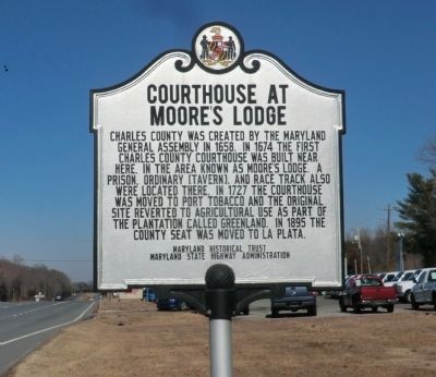
Photographed by Don Morfe, February 11, 2015
1. Courthouse at Moore's Lodge Marker
Erected 2010 by Maryland Historical Trust, Maryland State Highway Administration.
Topics and series. This historical marker is listed in these topic lists: Colonial Era • Settlements & Settlers. In addition, it is included in the Maryland Historical Trust series list. A significant historical year for this entry is 1658.
Location. 38° 30.21′ N, 76° 59.094′ W. Marker is in La Plata, Maryland, in Charles County. It is on Crain Highway (US 301). Touch for map. Marker is in this post office area: La Plata MD 20646, United States of America. Touch for directions.

Regionally, this marker is in the Washington Metropolitan Area and in Southern Maryland. It is also in the American South, specifically
this page online
Other nearby markers. At least 8 other markers are within 2 miles of this marker, measured as the crow flies: Surgeon General Revolutionary Army (approx. 1½ miles away); Remembrance (approx. 1.6 miles away); La Plata Elementary School (approx. 1.7 miles away); Mulberry Grove (approx. 1.8 miles away); a different marker also named Mulberry Grove (approx. 1.8 miles away); Star Memorial Garden (approx. 1.8 miles away); Old Durham Church, Episcopal - 1692 (approx. 1.8 miles away); John Hanson (approx. 1.8 miles away). Touch for a list and map of all markers in La Plata.
Another marker is no longer nearby. Chandler's Hope (was about 300 feet away, measured in a direct line but has been confirmed missing).
Credits. This page was last revised on December 27, 2024. It was originally submitted on March 3, 2015, by Don Morfe of Baltimore, Maryland. This page has been viewed 1,335 times since then and 65 times this year. Photo 1. submitted on March 3, 2015, by Don Morfe of Baltimore, Maryland. • Bill Pfingsten was the editor who published this page.
