Near Elizabethton in Carter County, Tennessee — The American South (East South Central)
Cedar Grove Cemetery
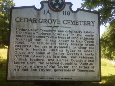
Photographed by Melanie Storie, circa June 2009
1. Cedar Grove Cemetery Marker
Erected by Tennessee Historical Commission. (Marker Number 1A 119.)
Topics and series. This historical marker is listed in these topic lists: African Americans • Cemeteries & Burial Sites. In addition, it is included in the Tennessee Historical Commission series list.
Location. 36° 19.517′ N, 82° 14.733′ W. Marker is near Elizabethton, Tennessee, in Carter County. It is on Southside Road, on the right when traveling east. Touch for map. Marker is in this post office area: Elizabethton TN 37643, United States of America.
this page online

Regionally, this marker is in East Tennessee and in the Tri-Cities Area. It is also in the American South, specifically in the Upper South, in Appalachia, and specifically in Southern Appalachia. Globally, it is in North America, the Western Hemisphere, the Western World, and the Anglosphere. Historically, it finds itself in what was once the original Cherokee Nation, the territory of the Mississippian Culture, one of the Confederate States of America, the State of Franklin, and the Antebellum South.
Other nearby markers. At least 8 other markers are within 2 miles of this marker, measured as the crow flies: Fort Watauga Monument (approx. 1.1 miles away); Monument to the Patriots (approx. 1.1 miles away); Gap Branch Clean Water Project (approx. 1.1 miles away); Revolutionary War Patriots (approx. 1.2 miles away); Sycamore Shoals of the Watauga (approx. 1.3 miles away); Uncovering the Past (approx. 1.3 miles away); The Taylor Family (approx. 1.3 miles away); Restoration of Sabine Hill (approx. 1.3 miles away). Touch for a list and map of all markers in Elizabethton.
Credits. This page was last revised on June 16, 2016. It was originally submitted on August 1, 2009, by Melanie Storie of Elizabethton, Tennessee. This page has been viewed 2,241 times since then and 34 times this year. Last updated on March 12, 2015, by J. Makali Bruton of Washington, District of Columbia. Photo 1. submitted on August 1, 2009, by Melanie Storie of Elizabethton, Tennessee. • Kevin W. was the editor who published this page.
