Yosemite National in Mariposa County, California — The American West (Pacific Coastal)
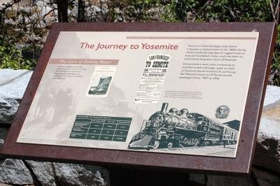
The Journey to Yosemite
Photographed by Eric Polk, June 2008
1. The Journey to Yosemite Marker
Click on photo to view photos and sketches seen on marker.
Entrepreneurs were soon competing to establish hotels and stage roads to cater to Yosemite-bound travelers. A rail line up the Merced Canyon to El Portal served passengers from 1907 to 1945.
The Lure of Falling Water
Reports of fabulous waterfalls tempted tourists to make the long and arduous trek to Yosemite. Engravings of waterfalls were among the first views of Yosemite ever published.
Early twentieth century Yosemite visitors could travel from San Francisco or Los Angeles to El Portal by train. From El Portal, they transferred to horse-drawn or motor carriages for the last few miles to Yosemite Valley.
Erected by Yosemite Fund.
Topics. This historical marker is listed in these topic lists: Environment • Industry & Commerce • Railroads & Streetcars. A significant historical year for this entry is 1907.
Location. 37° 43.439′ N, 119° 42.718′ W. Marker is in Yosemite National, California,
this page online

Regionally, this marker is in California’s Sierra Nevada. It is also in the American Mountain West. Globally, it is in North America, the Pacific Rim, the Western Hemisphere, the Western World, and the Anglosphere. Historically, it finds itself in what was once New Spain and also Mexico’s Alta California.
Other nearby markers. At least 8 other markers are within 4 miles of this marker, measured as the crow flies: Waterfalls of Yosemite Valley (here, next to this marker); Rewards of Travel (approx. 2 miles away); President Theodore Roosevelt & John Muir Meeting Site (approx. 2.9 miles away); A Storied Landscape (approx. 3.2 miles away); Disappearing Waterfalls (approx. 3.3 miles away); Glaciers at the Gate (approx. 3½ miles away); El Capitan (approx. 3½ miles away); A Varied View (approx. 3½ miles away).
Another marker is no longer nearby. Yosemite Valley's First Visit by White Men (was approx. 2 miles away but has been confirmed missing).
More about this marker. Click on "Nearby Markers" to view photos of Yosemite Valley, Half Dome and the waterfalls.
Related marker. Click here for another marker that is related to this marker. A marker regarding the Yosemite Valley Railroad.
Credits. This page was last revised on June 16, 2016. It was originally submitted on March 26, 2015, by Eric Polk of Lakewood, California. This page has been viewed 703 times since then and 44 times this year. Photo 1. submitted on March 26, 2015, by Eric Polk of Lakewood, California. • Syd Whittle was the editor who published this page.
Editor’s want-list for this marker. Wide area view of the marker and its surroundings. • Can you help?
