Old Port of Montreal in Montréal, Québec — Central Canada (French-Canadian)
Saint-Laurent Boulevard
Le Boulevard Saint-Laurent
Photographed by Barry Swackhamer, August 5, 2014
1. Saint-Laurent Boulevard Marker
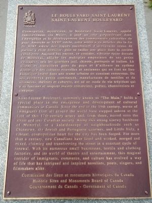
Saint-Laurent Boulevard, commonly known as “The Main,” holds a special place in the emergence and development of cultural communities in Canada. Since the end of the 19th century, waves of immigrants from all around the world have stepped ashore at the foot of this 17th-century artery and , from there, moved onto the street and into Canadian society. Along this strong sinewy backbone of Montréal, in a kaleidoscope of neighbourhoods such as Chinatown, the Jewish and Portuguese quarters, and Little Italy, a vibrant, cosmopolitain heart for the city has been forged. For more than a century, new Canadians have lived and worked, merged and mixed, claiming and transforming the street in a constant cycle of renewal. With its numerous small businesses, textile and clothing factories, and its world of theatre and entertainment, this magical corridor of immigrants, commerce and culture has evolved a way of life that has intrigued and inspired novelists, poets, singers, and filmmakers alike.
French:
Cosmopolite, mystérieux, le boulevard Saint-Laurent, appelé familièrement «la Main», a joué un rôle prépondérant dans
this page online
Erected by Historic Sites and Monument Board of Canada/Commission de lieux et monuments historique du Canada.
Topics and series. This historical marker is listed in this topic list: Roads & Vehicles. In addition, it is included in the Canada, Historic Sites and Monuments Board
Photographed by Barry Swackhamer, August 5, 2014
2. Saint-Laurent Boulevard Marker
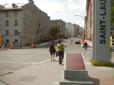
Location. 45° 30.321′ N, 73° 33.186′ W. Marker is in Montréal, Québec. It is in Old Port of Montreal. It is at the intersection of Boulevard Saint Laurent and Rue de la Commune Ouest, on the left when traveling east on Boulevard Saint Laurent. Touch for map. Marker is at or near this postal address: 199 Boulevard Saint Laurent, Montréal QC H2Y 2C5, Canada. Touch for directions.

Regionally, this marker is in Central Canada. Globally, it is in North America, the Western Hemisphere, and the Western World. Historically, it finds itself in what was once a British colony, the Viceroyalty of New France, the Haudenosaunee (Iroquois) Confederacy, and Rupert’s Land.
Other nearby markers. At least 8 other markers are within walking distance of this marker: Jeanne Mance (about 180 meters away, measured in a direct line); Here Stood the Residence of the Hon. John Richardson (about 180 meters away); Caserne 2 (about 210 meters away); Ici s’élevait la maison de Simon Fraser (about 210 meters away); Raphaël-Lambert Closse (about 210 meters away); La Rue Saint-Vincent (approx. 0.2 kilometers away); L'Hôtel Richelieu / Richelieu Hotel (approx. 0.2 kilometers away); St. Andrew's Society of Montréal (approx. 0.2 kilometers away). Touch for a list and map of all markers in Montréal.
More about this marker. This marker is in Parc Lineaire de la Commune.
Credits. This page was last revised on March 16, 2026. It was originally submitted on April 2, 2015, by Barry Swackhamer of Brentwood, California. This page has been viewed 945 times since then and 36 times this year. Photos: 1, 2. submitted on April 2, 2015, by Barry Swackhamer of Brentwood, California. • Andrew Ruppenstein was the editor who published this page.
