Near Great Falls in Cascade County, Montana — The American West (Mountains)
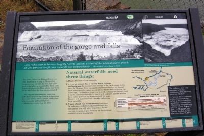
Formation of the Gorge and Falls
... the rocks seems to be most happily fixed to present a sheet of the whitest beaten froath for 200 yards in length and about 80 feet perpendicular. — Meriwether Lewis, June 13, 1805
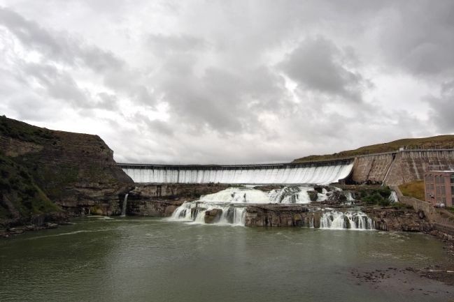
The Great Falls of the Missouri River was first described in writing by Meriwether Lewis on June 13, 1805. In 1915, the upper part of the falls was inundated by Ryan Dam to produce electricity. These photos are views of the falls before the dam was constructed.
... the irregular and somewhat projecting rocks below receives the water in it’s passage down and brakes it into a perfect white foam which assumes a thousand foams ...
— Meriwether Lewis, June 13, 1805
The explorers were very impressed with the narrowness of the Missouri gorge and the falls:
... I beheld those Cateracts with astonishment the whole of the water of this great river Confined in a Channel of 280 yards and pitching over a rock of 97 feet ... — William Clark, viewing the falls for the first time (June 17, 1805)
Natural waterfalls need three things:
- Plenty of water at least seasonally
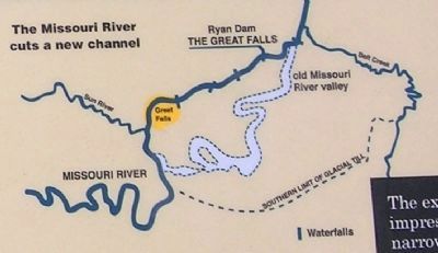
- A river or stream that is cutting down through the landscape due to some recent change in the the drainage. In this area, the Missouri River was apparently forced out of its old channel when a continental ice sheet moved into northern Montana during the last ice age. The displaced river went to work cutting a new channel, and it has not yet finished the job. In time, it will look more like the Missouri River valley upstream and downstream of the gorge. The river will meander across a broader valley with fewer waterfalls.
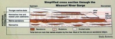
- A layer of rock that resists erosion more than the rocks above or below it. Hard sandstones are interlayered here with softer mudstones. As the river cuts its gorge, it gets “hung up” on the resistant sandstone layers, forming falls.
Topics and series. This historical marker is listed in these topic lists: Environment • Exploration • Waterways & Vessels. In addition, it is included in the Lewis & Clark Expedition series list. A significant historical date for this entry is June 13, 1805.
Location. 47° 34.098′ N, 111° 7.234′ W. Marker is near Great Falls, Montana, in Cascade County. Marker can be reached from Ryan Dam Road, 1.6 miles south of Morony Dam Road. The above directions are to the parking lot serving Ryan Dam and Ryan Island Park. Marker is located on Ryan Island Park, which is accessible from the parking lot by a pedestrian bridge crossing the Missouri River. Touch for map. Marker is in this post office area: Great Falls MT 59404, United States of America. Touch for directions.
Other nearby markers. At least 8 other markers are
within 6 miles of this marker, measured as the crow flies. The Smallest River Runs Through It (approx. 5.6 miles away); Where Does the Water Come From? (approx. 5.6 miles away); These Springs Have Witnessed... (approx. 5.6 miles away); Pure Springs Along the Missouri River (approx. 5.6 miles away); Giant Fountain (approx. 5.6 miles away); Of Special Concern (approx. 5.8 miles away); One of Many Firsts (approx. 5.8 miles away); The Army's Navy (approx. 5.9 miles away). Touch for a list and map of all markers in Great Falls.
Also see . . . Ryan Dam - Wikipedia entry. (Submitted on April 29, 2015.)
Credits. This page was last revised on June 16, 2016. It was originally submitted on April 29, 2015, by Duane Hall of Abilene, Texas. This page has been viewed 405 times since then and 11 times this year. Photos: 1, 2, 3, 4. submitted on April 29, 2015, by Duane Hall of Abilene, Texas.
Editor’s want-list for this marker. Photo of wide-view of marker and surrounding area. • Can you help?


