Kingston, Ontario — Central Canada (North America)
Strategic Importance / Importance Stratégique
Inscription.
English:
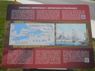
During the entire War of 1812, Canadian, British, and American land and naval forces campaigned across a vast territory from the Mississippi Valley, through the region south of Montreal, and well into the territories of the Atlantic coast. But the conflict’s outcome would be determined, in particular, by events on and around the Great Lakes. For the Anglo-Canadian forces, the St. Lawrence River and Lake Ontario was the strategic linkage for manpower and vital supplies for all inland points including the provincial capital, York, the Niagara Peninsula, and further garrisons west. Control of Lake Ontario would give crucial advantages in initiative, surprise, movement, and re-supply. During the war, British naval operations on the Lake Ontario were centered here at Point Frederick, at the confluence of the St. Lawrence and Catariqui Rivers at Lake Ontario. In 1812, the Provincial Marine operated only four vessels armed with 20 short-barreled guns. After May 1813, when the Royal Navy units under Commodore Sir James Yeo took command of the facility, it grew rapidly. At the end 1814, the Kingston Dockyard produced the largest naval Squadron on the Great Lakes, with 1,600 personnel serving on the massive flagship St. Lawrence, on four other ships, and four smaller vessels totaling 518 guns.
French:
Durant la guerre de 1812, des forces terrestres et navales américaines, britanniques, et canadiennes ont fait campagne sur un vaste territoire à partir de la vallée du Mississippi, en passant par la région au sud de Montréal, et jusqu’aux territories de la côte de l’Atlantique. Toutefois, de dénouement de la guerre a été determine par les événements sur et autour des Grands Lacs. Pour les forces tango-canadiennes, le fleuve St-Laurent et le lac Ontario constituaient le lien stratégique pour toute la main-d’oeuvre et l’approvisionnement indispensable destinés à tous les points à l’intérieur incluant la capitale provinciale de York, la péninsule du Niagara, et les garnisons plus à l’ouest. Le contrôle de lac Ontario apportait des advantages stratégiques quant à l’initiative, la surprise, le mouvement, et la ravitaillement. Pendant la guerre, les opérations navales britanniques sur le lac Ontario étaient basées ici, sur la pointe Frederick, à la confluence de la rivière Cataraqui, du fleuve St.-Laurent et du lac Ontario. En 1812, la Marine provinciale opérait seulement quatre navires armés de 20 canons à tube court. À partir de mai 1813, lorsque les unités de la Marine royale sous le Commodore Sir James Yeo prennent le commandement des installations, ces dernières connaissent une expansion rapide. À la fin de 1814, le chantier naval de Kingston avait le plus grand escadron naval de Grand
Lacs, avec 1600 personnes oeuvrant sur l’imposant navire-amiral St. Lawrence, quatre autres navires, et quatre plus petits vaisseaux ayant à bord un total de 518 canons.
Topics. This historical marker is listed in this topic list: War of 1812. A significant historical year for this entry is 1812.
Location. 44° 13.732′ N, 76° 28.023′ W. Marker is in Kingston, Ontario. Marker is on Point Frederick Drive, on the right when traveling south. Marker is on the Royal Military College of Canada grounds. Touch for map. Marker is at or near this postal address: 15 Point Frederick Drive, Kingston ON K7K 7B4,, Canada. Touch for directions.
Other nearby markers. At least 8 other markers are within walking distance of this marker. The Stone Frigate (within shouting distance of this marker); Kingston Navy Yard (about 90 meters away, measured in a direct line); Commodore’s Residence, 1815 (about 180 meters away); Point Frederick (about 210 meters away); Fort Frederick (about 240 meters away); Sir James Lucas Yeo (approx. 0.3 kilometers away); Point Frederick Buildings (approx. 0.3 kilometers away); Point Frederick Artillery Battery (approx. 0.3 kilometers away). Touch for a list and map of all markers in Kingston.
More about this marker. Kingston is independent from the surrounding Frontenac County.
Credits. This page was last revised on March 27, 2024. It was originally submitted on May 21, 2015, by Barry Swackhamer of Brentwood, California. This page has been viewed 327 times since then and 11 times this year. Photos: 1, 2. submitted on May 21, 2015, by Barry Swackhamer of Brentwood, California. • Andrew Ruppenstein was the editor who published this page.

