Ohsweken in Brant County, Ontario — Central Canada (North America)
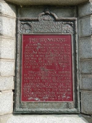
The Six Nations
Photographed by Barry Swackhamer, August 11, 2014
1. The Six Nations Marker

English:
Commemorating the loyal services and unswerving fidelity of the Six Nations of Iroquois Indians to the British Empire in the Seven Years War, 1755 - 1763, the War of the American Revolution, 1775 - 1783, and in the defence of Upper Canada in 1812 - 1814 and in 1837- 38.
French:
Erected 1934 by Historic Sites and Monument Board of Canada/Commission de lieux et monuments historique du Canada.
Topics and series. This historical marker is listed in these topic lists: Indigenous Peoples and Communities • War of 1812 • War, French and Indian • War, US Revolutionary. In addition, it is included in the Canada, Historic Sites and Monuments Board series list. A significant historical year for this entry is 1755.
Location. 43° 4.156′ N, 80° 7.103′ W. Marker is in Ohsweken, Ontario, in Brant County. It can be reached from
this page online

Regionally, this marker is in the Hamilton-Halton-Brant Area and in Southwestern Ontario. It is also in Central Canada. Globally, it is in North America, the Western Hemisphere, the Western World, and the Anglosphere. Historically, it finds itself in what was once a British colony, the Viceroyalty of New France, the Haudenosaunee (Iroquois) Confederacy, and Rupert’s Land.
Other nearby markers. At least 8 other markers are within 10 kilometers of this marker, measured as the crow flies: Ahyouwaeghs - John Brant (a few steps from this marker); The Six Nations War Memorial (a few steps from this marker); Thayendanega (Joseph Brant) (a few steps from this marker); Cogwagee • Tom Longboat (within shouting distance of this marker); E. Pauline Johnson (approx. 3.9 kilometers away); Chiefswood (approx. 3.9 kilometers away); a different marker also named E. Pauline Johnson (approx. 3.9 kilometers away); The Grand River Mission (approx.
Photographed by Barry Swackhamer, August 11, 2014
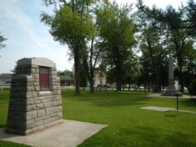
2. The Six Nations Marker
More about this marker. This marker is located in Six Nations Veteran's Park.
Also see . . .
1. Iroquois - Wikipedia. Wikipedia entry:
The Iroquois, also known as the Haudenosaunee, are a historically powerful and important northeast Native American confederacy. They were known during the colonial years to the French as the "Iroquois League" and later as the "Iroquois Confederacy", and to the English as the "Five Nations" (before 1722) and later as the "Six Nations", comprising the Mohawk, Onondaga, Oneida, Cayuga, Seneca, and Tuscarora nations... In 2010, more than 45,000 enrolled Six Nations people lived in Canada, and about 80,000 in the United States. (Submitted on May 25, 2015, by Barry Swackhamer of Brentwood, California.)
2. The Six Nations Confederacy During the American Revolution. National Park Service website entry:
The Treaty of Paris bought the war to an end in 1783. In this treaty however, neither the English nor the Americans had made provisions for their Six Nations allies. The Confederacy was forced to sign a separate treaty with the United States in 1784. This treaty was negotiated and signed at the ruinous Fort Stanwix, and resulted in the English allied Confederacy members giving up significant amounts of their traditional lands... (Submitted on May 25, 2015, by Barry Swackhamer of Brentwood, California.)
Credits. This page was last revised on October 31, 2022. It was originally submitted on May 25, 2015, by Barry Swackhamer of Brentwood, California. This page has been viewed 660 times since then and 30 times this year. Photos: 1, 2. submitted on May 25, 2015, by Barry Swackhamer of Brentwood, California. • Andrew Ruppenstein was the editor who published this page.
