Coteau-du-Lac in Vaudreuil-Soulanges, Québec — Central Canada (French-Canadian)
The “rigolet” canal
Le canal rigolet
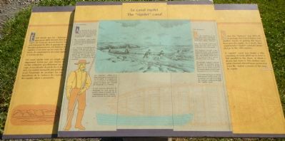
Since the “batteau” was difficult to portage, the French has to find another means of getting this heavy boat past the rapids. As a result, they constructed a “rigolet” canal at Coteau-du-Lac in the 18th century.
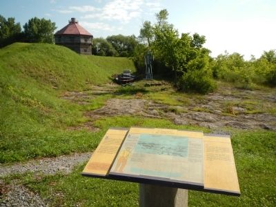
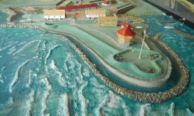
A “rigolet” canal was simply a dike consisting of rocks piled up to form a line parallel to the shore, at about a dozen feet from it. This shallow navigable channel offered boats protection from the violent currents of the nearby rapids.
The “batteau”
At the beginning of the 18th century, the French started to use a new type of boat, which they called a “batteau.”
Not only was the craft more stable than the canoe, but it could also carry more goods.
The “batteau” was like a flat bottomed barge with pointed ends. It was propelled by oar or pole, and could be fitted with a sail. A crew of 4 to 5 was required to man each boat.
The average “batteau” used on the upper St. Lawrence measured 9 to 12 metres in length and 1.5 to 2.4 metres across at its broadest point; it had a loading capacity of 3 to 5 tonnes.
It was often necessary to unload three-quarters of the cargo. and sometimes even all of it, so that the “batteau” could pass through the “rigolet” canal.
French:
Étant donné que les «batteaux» pouvaient difficilement être portages, les Français durent trouver une solution pour faciliter le passage de ces lourdes embarcations à la hauteur des rapides. C’est ainsi qu’au cours du 18ᵉ siècle, ils construisirent un canal rigolet à Coteau-du-lac.
Un canal rigolet était un simple endiguement formé par une chaine de roches entassées parallèlement au rivage, à une dizaine de pieds de ce dernier. Ce couloir navigable peu profond avait l’avantage de protéger les embarcations de la violence du courant des rapides situes à proximité.
Le «batteau»
Au tournant du 18ᵉ siècle, les Français commencent à utiliser un nouveau type d’embarcation qu’ils nomment tout simplement le «batteau»
Plus sécuritaire, cette embarcation permettait également de transporter plus de marchandises que le canot.
Le «batteau» ressemblait à une barge à fond plat avec des extrémités en forme de pointe. Il était propulsé à la rame ou à la perche et pouvait être muni d’une voile. Un équipage de 4 a 5 hommes suffisait à le manoeuvrer.
Les «bateaux» utilisés sur le haut Saint-Laurent mesuraient de 9 à 12 mètres de longueur par 1,5 à 2,4 mètres de largeur au centre et avant un capacité de charge de 3 à 5 tonnes.
Il était souvent nécessaire de décharger les trois quarts et parfois même la totalité de la cargaison pour qu’un «batteau» puisse franchir le canal rigolet.
Erected by Parks Canada / Parcs Canada.
Topics. This historical marker is listed in these topic lists: Forts and Castles • War of 1812 • Waterways & Vessels.
Location. 45° 17.222′ N, 74° 10.57′ W. Marker is in Coteau-du-Lac, Québec, in Vaudreuil-Soulanges. Marker can be reached from Chemin du Fleuve close to Rue du Fort, on the left when traveling south. Touch for map. Marker is at or near this postal address: 307 Chemin du Fleuve, Coteau-du-Lac QC J0P 1B0, Canada. Touch for directions.
Other nearby markers. At least 8 other markers are within walking distance of this marker. Why a canal at Coteau-du-Lac? (a few steps from this marker); The first lock canal in North America (a few steps from this marker); The Coteau-du-Lac rapids (a few steps from this marker); The construction of the canal (within shouting distance of this marker); Changes in the landscape (within shouting distance of this marker); A supply centre / Un poste de ravitaillement (within shouting distance of this marker); A canal excavated in the rock (within shouting distance of this marker); What is a lock canal? (within shouting distance of this marker). Touch for a list and map of all markers in Coteau-du-Lac.
More about this marker. This marker is located at Coteau-du-Lac National Historic Site.
Credits. This page was last revised on June 16, 2016. It was originally submitted on May 29, 2015, by Barry Swackhamer of Brentwood, California. This page has been viewed 371 times since then and 19 times this year. Photos: 1, 2, 3. submitted on May 29, 2015, by Barry Swackhamer of Brentwood, California. • Andrew Ruppenstein was the editor who published this page.


