Mukilteo in Snohomish County, Washington — The American West (Northwest)
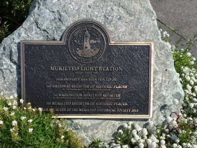
Mukilteo Light Station
Established 1906

Photographed by Craig Baker, December 24, 2025
1. Mukilteo Light Station Marker
This property has been placed on:
The National Register of Historic Places by the Department of the Interior and on the Washington Heritage Register by the Governor's Advisory Council on historic preservation.
The Mukilteo Register of Historic Places
Erected 2015 by Mukilteo Historical Society.
Topics. This historical marker is listed in this topic list: Waterways & Vessels.
Location. 47° 56.925′ N, 122° 18.368′ W. Marker is in Mukilteo, Washington, in Snohomish County. It is on Front Street. Touch for map. Marker is in this post office area: Mukilteo WA 98275, United States of America. Touch for directions.

Regionally, this marker is in the Puget Sound Region and in Greater Seattle. It is also on the American Pacific Coast, in the Pacific Northwest, and in the Lewis & Clark Corridor. Globally, it is in North America, in the Cascade Range, in the Inside Passage, on the Ring of Fire, on the Pacific Rim, in the Western Hemisphere, in the Western World, and in the Anglosphere.
Other nearby markers. At least 8 other markers are within walking
this page online
Photographed by Pat Filippone, May 29, 2015
2. Mukilteo Light Station Marker

October 24, 2016
3. Mukilteo Light Station Marker
The marker is to the right of the door.

Photographed by Pat Filippone, May 29, 2015
4. Mukilteo Light Station

Photographed by Pat Filippone, May 27, 2015
5. Mukilteo Light Station

Photographed by Pat Filippone, May 27, 2015
6. Mukilteo Light Station
Credits. This page was last revised on December 24, 2025. It was originally submitted on May 30, 2015, by Pat Filippone of Stockton, California. This page has been viewed 549 times since then and 24 times this year. Photos: 1. submitted on December 24, 2025, by Craig Baker of Sylmar, California. 2. submitted on May 30, 2015, by Pat Filippone of Stockton, California. 3. submitted on November 11, 2020. 4, 5, 6. submitted on May 30, 2015, by Pat Filippone of Stockton, California. • Andrew Ruppenstein was the editor who published this page.
