Mount Vernon in Rockcastle County, Kentucky — The American South (East South Central)
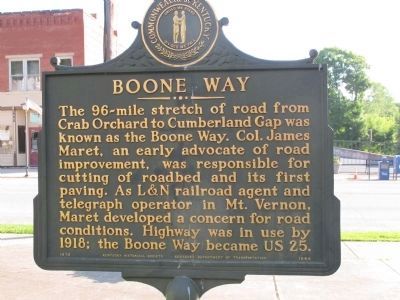
Boone Way
Erected 1979 by Kentucky Historical Society Kentucky Department of Transportation. (Marker Number 1644.)
Topics and series. This historical marker is listed in these topic lists: Roads & Vehicles • Settlements & Settlers. In addition, it is included in the Kentucky Historical Society series list. A significant historical year for this entry is 1918.
Location. 37° 21.171′ N, 84° 20.314′ W. Marker is in Mount Vernon, Kentucky, in Rockcastle County. Marker is on Main Street near Church Street, on the right when traveling east. Marker is one of several in the front lawn of the Rockcastle County Courthouse. It is often missed, as it is the back side of another marker. Touch for map. Marker is at or near this postal address: 205 E Main St, Mount Vernon KY 40456, United States of America. Touch for directions.
Other nearby markers. At least 8 other markers are within walking distance of this marker. Col. James Maret (1855- 1936) (here, next to this marker); Rockcastle County, 1810 (here, next to this marker); Rockcastle Co. War Memorial (here, next to this marker); Grand Army of the Republic (GAR) (a few steps from this marker); Cox Building History (within shouting distance of this marker); Fish – Hiatt Building (within shouting distance of this marker); Spout Spring Pioneer History (about 300 feet away, measured in a direct line); Bryant Building / Murder on Main Street (about 400 feet away). Touch for a list and map of all markers in Mount Vernon.
Credits. This page was last revised on June 16, 2016. It was originally submitted on June 19, 2015, by Rev. Ronald Irick of West Liberty, Ohio. This page has been viewed 512 times since then and 21 times this year. Photos: 1, 2. submitted on June 19, 2015, by Rev. Ronald Irick of West Liberty, Ohio. • Bill Pfingsten was the editor who published this page.

