Near North Myrtle Beach in Horry County, South Carolina — The American South (South Atlantic)
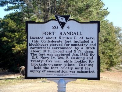
Fort Randall
Erected 1976 by the Horry County Historic Preservation Commission. (Marker Number 26-4.)
Topics. This historical marker is listed in these topic lists: Forts and Castles • War, US Civil. A significant historical year for this entry is 1863.
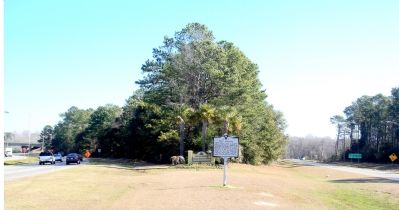
Location. 33° 50.7′ N, 78° 39.283′ W. Marker is near North Myrtle Beach, South Carolina, in Horry County. Marker is at the intersection of U.S. 17 and Sea Mountain Highway (South Carolina Highway 9), on the right when traveling north on U.S. 17. It is in the median formed by the Cherry Grove Beach off-ramp from northbound U.S. 17 to southbound Sea Mountain Highway. Touch for map. Marker is in this post office area: North Myrtle Beach SC 29582, United States of America. Touch for directions.
Other nearby markers. At least 5 other markers are within 4 miles of this marker, measured as the crow flies. Sonny’s Pavilion (approx. 1.4 miles away); Chestnut Consolidated School (approx. 1˝ miles away); Roberts Pavilion / Ocean Drive Pavilion (approx. 2.1 miles away); Rebecca Randall Bryan (approx. 3.2 miles away); Rev. George Whitefield (approx. 3.3 miles away).
Also see . . . Fort Randal, Little River Neck, Horry County, South Carolina. 2005 monograph by Ben Burroughs, Research Specialist at the Burroughs & Chapin Center for Marine and Wetland Studies, Coastal Carolina University. (Submitted on February 7, 2007.)
Additional keywords. Lieutenant William B. Cushing
Credits. This page was last revised on July 14, 2019. It was originally submitted on February 7, 2007, by J. J. Prats of Powell, Ohio. This page has been viewed 4,823 times since then and 111 times this year. Photos: 1, 2. submitted on February 7, 2007, by J. J. Prats of Powell, Ohio.
Editor’s want-list for this marker. Photos of the site • Can you help?

