Near Henrico in Henrico County, Virginia — The American South (Mid-Atlantic)
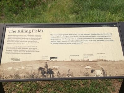
The Killing Fields
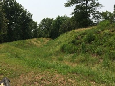
After the attack, killed and wounded soldiers covered the ground between the camera and the fort. By the time this photograph was taken, Federal soldiers had already begun to demolish the old Confederate wall—the wall that the Federals assaulted was almost twice as tall as seen today.
"The men nobly responded to their officers' call and pour over the edge of the ditch into the dry moat, and then, scrambling up the bank, some on hands and knees, some stepping on their bayonets thrust into the clay, some on each other's shoulders, the blue column mounts the parapet, lingers a moment in a fierce blaze of musketry on its crest, and finally, overflowing all barriers, pushes across the parade ground." William S. Hubbell, 21st Connecticut Infantry
Erected by Richmond National Battlefield Park.
Topics. This historical marker is listed in these topic lists: Forts and Castles • War, US Civil.
Location. 37° 25.551′ N, 77° 22.346′ W. Marker is near Henrico, Virginia, in Henrico County. Marker can be reached from Battlefield Park Road, 0.2 miles Picnic Road, on the right when traveling south. Marker is located along the ¼-mile spur trail and can be accessed by hiking the main trail at the Fort Harrison unit of Richmond National Battlefield Park. Touch for map. Marker is at or near this postal address: 8621 Battlefield Park Road, Henrico VA 23231, United States of America. Touch for directions.
Other nearby markers. At least 8 other markers are within walking distance of this marker. Union Entrenchments (a few steps from this marker); Confederate Trenches (within shouting distance of this marker); Grant Under Fire (within shouting distance of this marker); "The Big Guns Spoke" (within shouting distance of this marker); Bombproof and Casemate (within shouting distance of this marker); Bombproof (within shouting distance of this marker); The Fort Parapet (within shouting distance of this marker); Surprise Attack (about 300 feet away, measured in a direct line). Touch for a list and map of all markers in Henrico.
More about this marker. This marker replaced an older one at this location titled, "Braving the Fire" (see nearby markers)
Also see . . .
Richmond National Battlefield Park. (Submitted on July 6, 2015.)
Credits. This page was last revised on June 16, 2016. It was originally submitted on July 5, 2015, by Shane Oliver of Richmond, Virginia. This page has been viewed 338 times since then and 18 times this year. Photos: 1, 2, 3, 4. submitted on July 5, 2015, by Shane Oliver of Richmond, Virginia. • Bernard Fisher was the editor who published this page.


