Kingston in Plymouth County, Massachusetts — The American Northeast (New England)
The Brig Independence
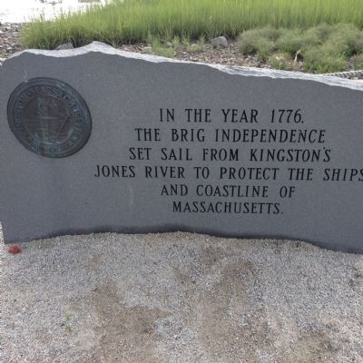
Photographed by Chris Connors
1. The brig Independence Marker
Topics. This historical marker is listed in these topic lists: War, US Revolutionary • Waterways & Vessels. A significant historical year for this entry is 1776.
Location. 41° 59.89′ N, 70° 42.625′ W. Marker is in Kingston, Massachusetts, in Plymouth County. It is on River Street. Touch for map. Marker is in this post office area: Kingston MA 02364, United States of America. Touch for directions.

Regionally, this marker is on the South Shore. It is also in the American Northeast, in New England, and on the Eastern Seaboard. Globally, it is in the North Atlantic Region, North America, the Western Hemisphere, the Western World, and the Anglosphere. Historically, it finds itself in what was once one of the original Thirteen Colonies.
Other nearby markers. At least 8 other markers are within 3 miles of this marker, measured as the crow flies: The Home of John Howland and his Wife (approx. 0.4 miles away); Historic Site of Home of Joseph Howland (approx. 0.4 miles away); North Plymouth 9-11 Memorial
this page online
Credits. This page was last revised on June 16, 2016. It was originally submitted on July 15, 2015, by Chris Connors of Tisbury, Massachusetts. This page has been viewed 804 times since then and 56 times this year. Photo 1. submitted on July 15, 2015, by Chris Connors of Tisbury, Massachusetts. • Bill Pfingsten was the editor who published this page.
