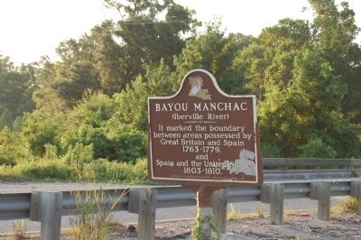
Baton Rouge in East Baton Rouge Parish, Louisiana — The American South (West South Central)
Bayou Manchac
(Iberville River)
Erected 1979 by Department of Culture, Recreation and Tourism.
Topics. This historical marker is listed in these topic lists: Government & Politics • Waterways & Vessels.
Location. 30° 20.591′ N, 90° 59.599′ W. Marker is in Baton Rouge, Louisiana, in East Baton Rouge Parish. Marker is on Airline Highway (U.S. 61) 0.2 miles south of Manchac Park Lane, in the median. On the East Baton Rouge Parish side of the Manchac Bridge. Touch for map. Marker is in this post office area: Baton Rouge LA 70817, United States of America. Touch for directions.
Other nearby markers. At least 8 other markers are within 6 miles of this marker, measured as the crow flies. William Bartram Trail (approx. 0.6 miles away); Joe Martin, Jr. (approx. 2.9 miles away); Tiger Bend Archaeological Site (approx. 3˝ miles away); The Ascension Parish Negro Fair Association, Inc. / Ascension Parish Negro Fairgrounds (approx. 3.6 miles away); Prairieville Cemetery (approx. 3.8 miles away); The Purple Heart Trail (approx. 4 miles away); Bayou Fountain (approx. 5.1 miles away); Original Site/Donors of Land (approx. 6 miles away). Touch for a list and map of all markers in Baton Rouge.
More about this marker. VERY busy major US Highway, please BE CAREFUL.
Also see . . .
1. Bayou Manchac. (Submitted on February 4, 2018, by Kenneth Ramagost of Unknown, Louisiana.)
2. History of Louisiana The Spanish Dominarion. Fort Manchac page 127, Fort Bute page 132 (Submitted on February 19, 2018, by Kenneth Ramagost of Unknown, Louisiana.)
Credits. This page was last revised on May 30, 2022. It was originally submitted on July 19, 2015. This page has been viewed 908 times since then and 36 times this year. Last updated on July 20, 2015. Photo 1. submitted on July 19, 2015. • Bernard Fisher was the editor who published this page.
