South Park in Buffalo in Erie County, New York — The American Northeast (Mid-Atlantic)
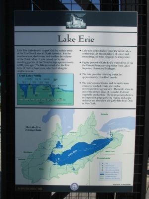
Lake Erie
The Industrial Heritage Trail
Great Lakes Profile.
Lake Superior, elevation 601.1 ft., depth 1,330 ft.; St Mary's River; Lake Huron, Lake Michigan, elevation 577.5 ft., depth 750 ft., depth 923 ft.; St Clair River, Lake St. Clair, Detroit River, elevation 572 ft.; Lake Erie, elevation 569.2 ft., depth 210 ft.; Niagara River; Niagara Falls; Lake Ontario, elevation 243.3 ft., depth 802 ft.; St. Lawrence River.
Diagram courtesy of Michigan Sea Grant.
♦ Lake Erie is the shallowest of the Great Lakes, containing 128 trillion galons of water, and measuring 241 miles long and 57 miles wide.
♦ Eighty percent of Lake Erie's water flows in via the Detroit River, carrying water from Lakes Superior, Huron, and Michigan.
♦ The lake provides drinking water for approximately 11 million people.
♦ The lake's microclimates and formerly more extensive lakebed create a favorable environment for agriculture. The north shore is one of the richest areas of Canada's fruit and vegetable production. The southeastern shore is an important grape growing region, and apple orchards are abundant along the lake from Ohio to New York.
The Lake Erie Drainage Basin. Image Source: Sea Grant, Michigan.
Erected by The Industrial Heritage Committee, Inc.
Topics. This historical marker is listed in this topic list: Environment.
Location. 42° 50.047′ N, 78° 51.291′ W. Marker is in Buffalo, New York, in Erie County. It is in South Park. Marker is on Fuhrmann Boulevard, ¼ mile south of Tifft Street, on the right when traveling south. Touch for map. Marker is in this post office area: Buffalo NY 14203, United States of America. Touch for directions.
Other nearby markers. At least 8 other markers are within walking distance of this marker. The Great Lakes (here, next to this marker); Early Lake Erie Water Craft (here, next to this marker); Improvements in Ship Design (here, next to this marker); The Union Ship Canal (a few steps from this marker); The Lehigh Portland Cement Company (a few steps from this marker); Bethlehem Steel in Lackawanna (a few steps from this marker); a different marker also named Bethlehem Steel in Lackawanna (a few steps from this marker); a different marker also named Bethlehem Steel in Lackawanna (a few steps from this marker). Touch for a list and map of all markers in Buffalo.
Credits. This page was last revised on February 16, 2023. It was originally submitted on July 23, 2015, by Anton Schwarzmueller of Wilson, New York. This page has been viewed 285 times since then and 8 times this year. Photos: 1, 2. submitted on July 23, 2015, by Anton Schwarzmueller of Wilson, New York.

