Sibley in Jackson County, Missouri — The American Midwest (Upper Plains)
Fort Osage
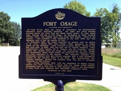
On June 23-24, 1804 the Corps of Volunteers for Northwestern Discovery spent Saturday afternoon, the night and early Sunday morning across the river from the bluffs which would, in four years time, become the site of Fort Osage. On September 8, 1808 General William Clark, now looking down those very bluffs, wrote in his journal “…this situation I had examined in the year 1804 and was delighted with it and am equally so now…”
In September 1806, the Corps concluded its mission with its return to St. Louis. March 1807 finds William Clark appointed as Indian Agent for the Territory. Clark returned to these bluffs, known as the rendezvoused with Captain Eli B. Clemson and his Company. George Sibley and Rueben Lewis and began the construction of Fort Osage. The government Indian Trade House was protected by Clemson’s troops who were quartered in the Redoubt. This compound included four blockhouses, soldiers huts and officer’s quarters with a fifth blockhouse located on the northern point of the bluff. The fortifications and adjacent buildings, gardens and cropland made this fort a veritable “Gibraltar of the Frontier.”
Also, during September 1808, with the assistance of Nathan Boone, Daniel’s so, Clark concluded a treaty with the Osage tribal leaders persuading them to cede much of their Missouri lands to the government on what Clark later admitted were shamefully inadequate terms.
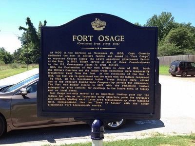
At 9:00 in the morning on November 13, 1808, Capt. Clemson dedicated the fort in military fashion and named it “Fort Osage”, so reported George Sibley the newly appointed government Factor at the Fort. In 1825, Sibley served as one of the three Commissioners on the U.S. Government Santa Fe Trail Survey.
With the Declaration of War with Britain in June of 1812, both the Military Garrison and the Indian trade operations were temporarily transferred away from the Fort. At the conclusion of the War in 1815, the Fort was re-garrisoned and the trade with the Indians reopened.
By 1822, all U.S. Government Indian Trade Houses were closed due to the pressure placed upon Congress by private fur companies. The Fort was finally closed in 1827 with the remaining lumber salvaged by area settlers for dwellings in the future town of Sibley and on local farms.
Fort Osage not only served as an important trading post for the Indians but also as an important early departure point for travelers and pioneers heading west. Later town replacements up river included first, Independence, then the “Town of Kansas” with newly established Fort Leavenworth nearby.
Erected 2008 by Native Sons and Daughters of Kansas City.
Topics and series. This historical marker is listed in these topic lists: Exploration • Forts and Castles • Native Americans • Settlements & Settlers. In addition, it is included in the Kansas City - Native Sons and Daughters of Greater Kansas City, and the Lewis & Clark Expedition series lists. A significant historical year for this entry is 1804.
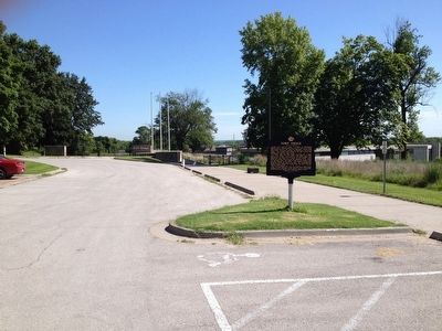
Location. 39° 11.155′ N, 94° 11.616′ W. Marker is in Sibley, Missouri, in Jackson County. Marker is on Osage Street, on the right when traveling north. Touch for map. Marker is in this post office area: Sibley MO 64088, United States of America. Touch for directions.
Other nearby markers. At least 8 other markers are within 8 miles of this marker, measured as the crow flies. Events at Fort Osage (about 500 feet away, measured in a direct line); Restoration of Fort Osage (about 700 feet away); a different marker also named Fort Osage (approx. 2.9 miles away); Santa Fe Trail (approx. 3.3 miles away); a different marker also named Santa Fe Trail (approx. 6.4 miles away); Engagement at the Little Blue (approx. 7.2 miles away); Potawatomi Trail of Death March (approx. 7.6 miles away); The Lewis and Clark Expedition Across Missouri (approx. 7.8 miles away). Touch for a list and map of all markers in Sibley.
Credits. This page was last revised on December 3, 2023. It was originally submitted on July 31, 2015, by Michael W. Kruse of Kansas City, Missouri. This page has been viewed 473 times since then and 19 times this year. Photos: 1, 2, 3. submitted on July 31, 2015, by Michael W. Kruse of Kansas City, Missouri. • Bill Pfingsten was the editor who published this page.


