Guernsey in Platte County, Wyoming — The American West (Mountains)
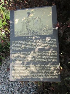
Laramie Peak
The sight points to Laramie Peak, altitude 10,247 feet, the highest elevation in the Laramie Range. These mountains were originally called the Black Hills, a name derived from the dark appearance of their evergreen forests as noted from far to the eastward by westward-journeying mountain men. Only the northern end of the range, in northeastern Wyoming and western South Dakota, is now known as the Black Hills.
Although the name of that more legendary than historic figure, Lacques LaRamie, has been given to numerous features of Wyoming geography, apparently this mountain was the first to be so designated. Looming on a distant horizon, that major natural landmark won historic significance through being cited time and again – in the journals, diaries and letters of Oregon Trail travelers – as first evidence of a successful high plains crossing and impending entry into the Rocky Mountains.
One who so recorded a sighting of Laramie Peak, and whose transit triangulations would later make the mountain an important cartographic reference point, was famed Dr. Francis V. Hayden of the U.S. Geological Survey. He wrote, in 1869: “From our camp on the Laramie we enjoyed one of the beautiful sunsets which are not uncommon in this western country. But this was a rare occasion, for the sun passed directly behind the summit of Laramie Peak. The whole range was gilded with golden light, and the haziness of the atmosphere gave to the whole a deeper beauty. Such a scene as this could occur but once in a lifetime.”
Topics. This historical marker is listed in this topic list: Natural Features. A significant historical year for this entry is 1869.
Location. 42° 16.148′ N, 104° 44.48′ W. Marker is in Guernsey, Wyoming, in Platte County. Marker is on S Wyoming Avenue, on the left when traveling south. Touch for map. Marker is in this post office area: Guernsey WY 82214, United States of America. Touch for directions.
Other nearby markers. At least 8 other markers are within walking distance of this marker. The Burlington – Northern Railroad (here, next to this marker); Guernsey – Frederick Ranch (here, next to this marker); Sand Point (here, next to this marker); Register Cliffs (a few steps from this marker); Guernsey Pipeline Station (a few steps from this marker); North Platte River (a few steps from this marker); Fort Laramie (a few steps from this marker); Mexican Hill (a few steps from this marker). Touch for a list and map of all markers in Guernsey.
Credits. This page was last revised on June 16, 2016. It was originally submitted on August 9, 2015, by Bill Coughlin of Woodland Park, New Jersey. This page has been viewed 447 times since then and 10 times this year. Photos: 1, 2, 3. submitted on August 9, 2015, by Bill Coughlin of Woodland Park, New Jersey.


