Nancy in Pulaski County, Kentucky — The American South (East South Central)
Confederate Defense Line / The Forces Move In / Battle of Mill Springs / Aftermath
Inscription.
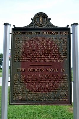
Confederate Defense Line
Late in 1861, Confederates sought to prevent Union forces from occupying strategic points in Kentucky and Tennessee, to maintain rail shipments of vital Confederate supplies from Virginia south and west and to set up bases for future offensive thru Kentucky and Ohio to divide eastern and western Union states. With those aims the Confederate Defense Line was formed from the Big Sandy Valley in east Kentucky thru Cumberland Gap, Mill Springs on Cumberland River, Bowling Green on L&N Ry. to Columbus, Ky. on the Mississippi River.
The Forces Move In
Brig. Gen. Felix K. Zollicoffer in Nov. 1861 built CSA bases at Mill Springs and across Cumberland at Beech Grove, as part of plan. Maj. Gen. George B. Crittenden took command Dec. 13, 1861. On Jan. 11, 1862 Union forces under Brig. Gen. George H. Thomas started from Lebanon, Ky. to join the Federals under Brig. Gen. Albin Schoepf at Somerset and to attack the Confederate base at Mill Springs. On Jan. 19 Gen. Crittenden moved out with his CSA troops to prevent the Union forces under Gen. Thomas from joining US army at Somerset.
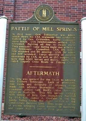
Battle of Mill Springs
In first hour, Gen. Zollicoffer was killed, which threw his CSA regiments into confusion. Rallied by Gen. Crittenden, battle continued three hours. USA reinforcements arrived, CSA retreated, fighting all day to reach river. They evacuated camp during night and withdrew into Tennessee. Casualties: CSA 125 killed, 309 wounded and 99 missing; USA 39 killed and 207 wounded. Large quantity of supplies abandoned by CSA, as well as 150 wagons and more than 1,000 horses and mules. Battle also called Logan’s Cross Roads or Fishing Creek.
Aftermath
The way was opened for the Union to advance into Eastern Tennessee. Lack of provisions, bad roads and difficulty of crossing river made such advance impractical. Gen. Thomas’ command joined Gen. Buell’s Union force in move on Nashville. This Mill Springs victory with defeat of Brig. Gen. Humphrey Marshall by Col. James A. Garfield in the Big Sandy Valley broke the right section of the Confederate Defense Line. Thus began a series of events bringing Union control of Kentucky and upper Miss. River in first year of war.
Erected 1965 by Kentucky Historical Society and Kentucky Department of Highways. (Marker Number 863.)
Topics and series. This historical marker is listed in this topic list: War, US Civil. In addition, it is included in the Kentucky Historical Society series list. A significant historical month for this entry is November 1861.
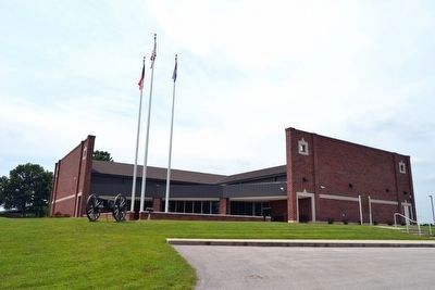
Location. 37° 4.131′ N, 84° 44.152′ W. Marker is in Nancy, Kentucky, in Pulaski County. Marker can be reached from State Highway 80, 0.3 miles east of State Highway 235, on the left when traveling east. Marker is located near the entrance to the Mill Springs Battlefield Visitor Center & Museum. Touch for map. Marker is at or near this postal address: 9020 Kentucky 80, Nancy KY 42544, United States of America. Touch for directions.
Other nearby markers. At least 8 other markers are within walking distance of this marker. A Hard March (a few steps from this marker); A National Cemetery System (about 500 feet away, measured in a direct line); Mill Springs National Cemetery (about 500 feet away); Balie Peyton, Jr. (1833-1862) (approx. 0.9 miles away); Battle on a Sabbath Morn (approx. 0.9 miles away); Melee at the Fence (approx. 0.9 miles away); The Ravine (approx. 0.9 miles away); Fix Bayonets, Charge! (approx. 0.9 miles away). Touch for a list and map of all markers in Nancy.
Also see . . . Experience Mill Springs Battlefield. Official website of the Mill Springs Battlefield Association. (Submitted on September 10, 2015.)
Credits. This page was last revised on April 2, 2024. It was originally submitted on September 10, 2015, by Duane Hall of Abilene, Texas. This page has been viewed 387 times since then and 15 times this year. Photos: 1, 2, 3. submitted on September 10, 2015, by Duane Hall of Abilene, Texas.


